Trail Walking Auzat-la-Combelle - La croix d'Auzat - Photo
 tracegps
tracegps

User

© OpenStreetMap contributors
Length
Length
11.3 km
Max alt
Max alt
699 m
Uphill gradient
Uphill gradient
328 m
Km-Effort
Km-Effort  
15.7 km
Min alt
Min alt
391 m
Downhill gradient
Downhill gradient
333 m
Boucle
Boucle
Yes
Creation date :
2014-12-10 00:00:00.0
Updated on :
2014-12-10 00:00:00.0

(0 Reviews)

Walking
Walking
3h15
Difficulty : Difficult

Scan this QR Code to open this trail in the SityTrail application

FREE GPS app for hiking

Logo SityTrail SityTrail

IGN / Geographical institutes

Download SityTrail from the App Store Download SityTrail from Google Play

Logo SityTrail SityTrail World

The world is yours!

Download SityTrail from the App Store Download SityTrail from Google Play Download SityTrail on Huawei AppGallery

About

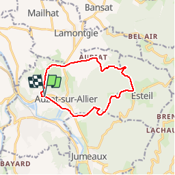
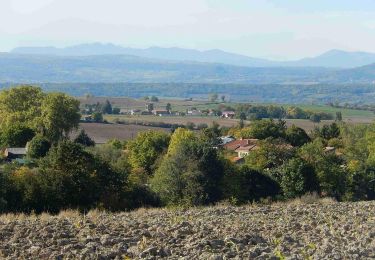
Trail Walking of 11.3 km to be discovered at Auvergne-Rhône-Alpes, Puy-de-Dôme, Auzat-la-Combelle. This trail is proposed by tracegps.

Description

Depuis le parking, face à la mairie d'Auzat, on s'élève imperceptiblement jusqu'aux premiers contreforts du Livradois. Balade numérisée sur le terrain par Jean louis Phillipart. Retrouvez cette randonnée dans le topo Guide Chamina Autour de Clermont.

Elevation profile

Photos

Positioning

Country:
France
Region :
Auvergne-Rhône-Alpes
Department/Province :
Puy-de-Dôme
Municipality :
Auzat-la-Combelle
Location:
Unknown
Start:(UTM)
524812 ; 5033184 (31T) N.

Trails nearby

Trail Walking Auzat-la-Combelle - Auzat_Croix - Photo
Walking
GUIDE
jagarnier

Walking

Medium
(1)
Auzat-la-Combelle, Auvergne-Rhône-Alpes, Puy-de-Dôme, France
12.3 km | 17 km-effort
3h 30min
Yes
Trail On foot Jumeaux - Saint Jean Saint Gervais - Photo
On foot
PRO

On foot

Medium
Jumeaux, Auvergne-Rhône-Alpes, Puy-de-Dôme, France
15.2 km | 24 km-effort
5h 24min
No
Trail On foot Esteil - La Croix d'Auzat - Photo
On foot
PRO

On foot

Easy
Esteil, Auvergne-Rhône-Alpes, Puy-de-Dôme, France
12.1 km | 16.7 km-effort
3h 47min
Yes
Trail On foot Lamontgie - Notre-Dame de Mailhat - Photo
On foot
PRO

On foot

Easy
Lamontgie, Auvergne-Rhône-Alpes, Puy-de-Dôme, France
8.4 km | 10.5 km-effort
2h 23min
Yes
Trail Quad Brassac-les-Mines - Sans titre - Photo
Quad
O.R.

Quad

Easy
(1)
Brassac-les-Mines, Auvergne-Rhône-Alpes, Puy-de-Dôme, France
90 km | 120 km-effort
3h 20min
Yes
Trail Walking Nonette-Orsonnette - Nonette_Val_Allier - Photo
Walking
GUIDE
jagarnier

Walking

Medium
(1)
Nonette-Orsonnette, Auvergne-Rhône-Alpes, Puy-de-Dôme, France
9.9 km | 13.4 km-effort
3h 0min
Yes
Trail Walking Jumeaux - Jumeaux_St_Jean - Photo
Walking
GUIDE
jagarnier

Walking

Difficult
Jumeaux, Auvergne-Rhône-Alpes, Puy-de-Dôme, France
15.5 km | 24 km-effort
4h 45min
Yes
Trail Walking Bansat - chez achille et rosalie - le tour de bansat - Photo
Walking
Alain Boyer

Walking

Medium
Bansat, Auvergne-Rhône-Alpes, Puy-de-Dôme, France
6.2 km | 8.2 km-effort
1h 43min
Yes
Trail Walking Le Breuil-sur-Couze - Breuil_Couze_Puy_Joux - Photo
Walking
GUIDE
jagarnier

Walking

Easy
Le Breuil-sur-Couze, Auvergne-Rhône-Alpes, Puy-de-Dôme, France
7.2 km | 8.2 km-effort
2h 15min
Yes


Close
My subscriptions