Trail Walking Le Bas Ségala - Vallée de l'Aveyron - Photo

Vallée de l'Aveyron

 tracegps
tracegps

User

© OpenStreetMap contributors
Length
Length
9.2 km
Max alt
Max alt
562 m
Uphill gradient
Uphill gradient
331 m
Km-Effort
Km-Effort  
13.6 km
Min alt
Min alt
337 m
Downhill gradient
Downhill gradient
333 m
Boucle
Boucle
Yes
Creation date :
2014-12-10 00:00:00.0
Updated on :
2014-12-10 00:00:00.0

(0 Reviews)

Walking
Walking
3h00
Difficulty : Medium

Scan this QR Code to open this trail in the SityTrail application

FREE GPS app for hiking

Logo SityTrail SityTrail

IGN / Geographical institutes

Download SityTrail from the App Store Download SityTrail from Google Play

Logo SityTrail SityTrail World

The world is yours!

Download SityTrail from the App Store Download SityTrail from Google Play Download SityTrail on Huawei AppGallery

About

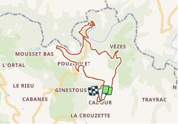
Trail Walking of 9.2 km to be discovered at Occitania, Aveyron, Le Bas Ségala. This trail is proposed by tracegps.

Description

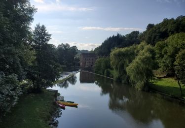
Départ du petit village Cadour (Commune, 3 km de La Bastide L'Evêque). Descendre dans la Vallée de l'Aveyron, à travers bois, jusqu'au Pont du Cayla (photo). Longer l'Aveyron, suivre longtemps ses méandres par un petit sentier, avant de regagner le plateau et Cadour.

Elevation profile

Photos

Positioning

Country:
France
Region :
Occitania
Department/Province :
Aveyron
Municipality :
Le Bas Ségala
Location:
La Bastide-l'Évêque
Start:(UTM)
433040 ; 4910919 (31T) N.

Trails nearby

Trail Electric bike Brandonnet - Aveyron pont de cayra - Photo
Electric bike
jdaviere

Electric bike

Medium
Brandonnet, Occitania, Aveyron, France
34 km | 47 km-effort
2h 30min
Yes
Trail Running Brandonnet - brandonnet j1 - Photo
Running
jdaviere

Running

Very easy
Brandonnet, Occitania, Aveyron, France
4.7 km | 6.7 km-effort
59min
Yes
Trail Car Rieupeyroux - negrefoylt 12 - Photo
Car
saegaert

Car

Very easy
Rieupeyroux, Occitania, Aveyron, France
54 km | 70 km-effort
3h 0min
No
Trail Walking Compolibat - compolibat  - Photo
Walking
claudesauzay

Walking

Very easy
Compolibat, Occitania, Aveyron, France
5.3 km | 7.5 km-effort
1h 55min
Yes
Trail Walking Le Bas Ségala - LA BASTIDE L'EVEQUE ET MARTINET DE LA RAMONDE - Photo
Walking
BESSOU1294

Walking

Easy
Le Bas Ségala, Occitania, Aveyron, France
5.7 km | 7.5 km-effort
1h 58min
Yes
Trail Walking Le Bas Ségala - la Bastide L'Evêque martinet  - Photo
Walking
BESSOU1294

Walking

Medium
Le Bas Ségala, Occitania, Aveyron, France
9.2 km | 13.3 km-effort
2h 53min
Yes
Trail Running Brandonnet - jogging brandonnet j13 - Photo
Running
jdaviere

Running

Very easy
Brandonnet, Occitania, Aveyron, France
8.3 km | 10.6 km-effort
1h 9min
Yes
Trail Walking Brandonnet - cayla à pieds - Photo
Walking
jdaviere

Walking

Medium
Brandonnet, Occitania, Aveyron, France
7.8 km | 10.9 km-effort
1h 20min
Yes
Trail Running Brandonnet - footing j7 - Photo
Running
jdaviere

Running

Easy
Brandonnet, Occitania, Aveyron, France
8.5 km | 10.6 km-effort
1h 0min
Yes


Close
My subscriptions