


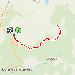
BONNEVAL SUR ARC - Lac du Pys.

AndreLACOMBE
User

Length
15 km

Max alt
2715 m

Uphill gradient
513 m
Km-Effort
22 km

Min alt
2473 m

Downhill gradient
511 m
Boucle
Yes
Creation date :
2019-01-15 15:29:31.632
Updated on :
2019-01-15 15:29:31.632
7h09
Difficulty : Medium

FREE GPS app for hiking
 SityTrail
IGN / Geographical institutes
SityTrail Plus
The world is yours!
About
Trail Walking of 15 km to be discovered at Auvergne-Rhône-Alpes, Savoy, Bonneval-sur-Arc. This trail is proposed by AndreLACOMBE.
Description
Parking Pont de l'Oulietta 2476 m (route de l'Iseran) puis Plan des Eaux 2695 m et lac du Pys 2663m. Retour par le même itinéraire.
Photos


Positioning
Country:
France
Region :
Auvergne-Rhône-Alpes
Department/Province :
Savoy
Municipality :
Bonneval-sur-Arc
Location:
Unknown
Start:(Dec)
Start:(UTM)
346871 ; 5029091 (32T) N.
Comments