Trail Running Saint-Cézaire-sur-Siagne - Les Allumes de la Pleine Lune 2009 - Photo
 tracegps
tracegps

User

© OpenStreetMap contributors
Length
Length
48 km
Max alt
Max alt
1039 m
Uphill gradient
Uphill gradient
1528 m
Km-Effort
Km-Effort  
68 km
Min alt
Min alt
228 m
Downhill gradient
Downhill gradient
1523 m
Boucle
Boucle
Yes
Creation date :
2014-12-10 00:00:00.0
Updated on :
2014-12-10 00:00:00.0

(0 Reviews)

Running
Running
7h00
Difficulty : Difficult

Scan this QR Code to open this trail in the SityTrail application

FREE GPS app for hiking

Logo SityTrail SityTrail

IGN / Geographical institutes

Download SityTrail from the App Store Download SityTrail from Google Play

Logo SityTrail SityTrail World

The world is yours!

Download SityTrail from the App Store Download SityTrail from Google Play Download SityTrail on Huawei AppGallery

About

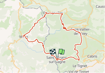
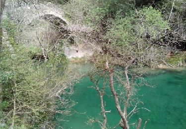
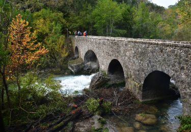
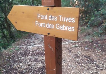
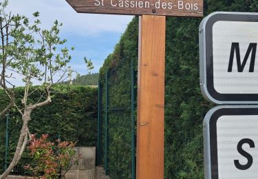
Trail Running of 48 km to be discovered at Provence-Alpes-Côte d'Azur, Maritime Alps, Saint-Cézaire-sur-Siagne. This trail is proposed by tracegps.

Description

Rando Nocturne à allure libre de 47km autour de la Siagne, 10eme edition. Certaines portions du parcours ne sont ouvertes que le jour de la Rando. Toutes les infos sont ICI.

Elevation profile

Photos

Positioning

Country:
France
Region :
Provence-Alpes-Côte d'Azur
Department/Province :
Maritime Alps
Municipality :
Saint-Cézaire-sur-Siagne
Location:
Unknown
Start:(UTM)
322039 ; 4835721 (32T) N.

Trails nearby

Trail On foot Tanneron - La chapelle de St Cassien des bois, le pont détruit et au fil de l'eau - Photo
On foot
boulinevelyne

On foot

Easy
(5)
Tanneron, Provence-Alpes-Côte d'Azur, Var, France
7.3 km | 10.3 km-effort
2h 19min
Yes
Trail On foot Le Tignet - Val de Siagne - Photo
On foot
PRO

On foot

Easy
Le Tignet, Provence-Alpes-Côte d'Azur, Maritime Alps, France
6.5 km | 9.5 km-effort
2h 9min
Yes
Trail Walking Saint-Cézaire-sur-Siagne - Col de Cabris - Photo
Walking
jlrayon

Walking

Easy
(1)
Saint-Cézaire-sur-Siagne, Provence-Alpes-Côte d'Azur, Maritime Alps, France
7.3 km | 9.7 km-effort
3h 0min
Yes
Trail Walking Montauroux - Monteroux Gorges de la Siagne 04.04.2015 - Photo
Walking
fredetpascale

Walking

Easy
(1)
Montauroux, Provence-Alpes-Côte d'Azur, Var, France
11.8 km | 16.4 km-effort
3h 26min
Yes
Trail Walking Saint-Cézaire-sur-Siagne - st cezaire siagne - Photo
Walking
pjjrevrard

Walking

Very easy
(1)
Saint-Cézaire-sur-Siagne, Provence-Alpes-Côte d'Azur, Maritime Alps, France
6.9 km | 11.4 km-effort
2h 42min
No
Trail Walking Saint-Cézaire-sur-Siagne - Saint Cézaire sur Siagne - Pont des Tuves - Chapelle St Saturnin - Photo
Walking
LtZIP

Walking

Medium
Saint-Cézaire-sur-Siagne, Provence-Alpes-Côte d'Azur, Maritime Alps, France
13.6 km | 19.9 km-effort
4h 30min
Yes
Trail Walking Saint-Cézaire-sur-Siagne - Gorges de Siagne - Photo
Walking
PVERTICAL

Walking

Medium
Saint-Cézaire-sur-Siagne, Provence-Alpes-Côte d'Azur, Maritime Alps, France
11.7 km | 19.4 km-effort
3h 38min
Yes
Trail Walking Montauroux - z le bas défens à Montauroux 23-05-23 - Photo
Walking
cb8310

Walking

Medium
Montauroux, Provence-Alpes-Côte d'Azur, Var, France
5.3 km | 6.6 km-effort
2h 2min
Yes
Trail Walking Le Tignet - circuit du val de Siagne - Photo
Walking
56jj

Walking

Easy
(1)
Le Tignet, Provence-Alpes-Côte d'Azur, Maritime Alps, France
7.4 km | 10.5 km-effort
4h 41min
Yes


Close
My subscriptions