


Vernettes - aiguille Grive

cron
User
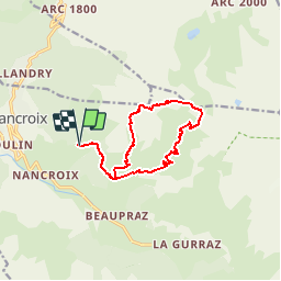

Length
12.4 km

Max alt
2699 m

Uphill gradient
944 m
Km-Effort
25 km

Min alt
1766 m

Downhill gradient
953 m
Boucle
Yes
Creation date :
2019-01-15 15:46:39.718
Updated on :
2019-01-15 15:46:39.718
5h00
Difficulty : Medium

FREE GPS app for hiking
 SityTrail
IGN / Geographical institutes
SityTrail Plus
The world is yours!
About
Trail Walking of 12.4 km to be discovered at Auvergne-Rhône-Alpes, Savoy, Peisey-Nancroix. This trail is proposed by cron.
Positioning
Country:
France
Region :
Auvergne-Rhône-Alpes
Department/Province :
Savoy
Municipality :
Peisey-Nancroix
Location:
Unknown
Start:(Dec)
Start:(UTM)
326873 ; 5045421 (32T) N.
Comments