Trail Mountain bike Chemaudin et Vaux - Les Ruisseaux de l'Ouest - Photo
 tracegps
tracegps

User

© OpenStreetMap contributors
Length
Length
40 km
Max alt
Max alt
311 m
Uphill gradient
Uphill gradient
776 m
Km-Effort
Km-Effort  
51 km
Min alt
Min alt
207 m
Downhill gradient
Downhill gradient
776 m
Boucle
Boucle
Yes
Creation date :
2014-12-10 00:00:00.0
Updated on :
2014-12-10 00:00:00.0

(0 Reviews)

Mountain bike
Mountain bike
4h00
Difficulty : Difficult

Scan this QR Code to open this trail in the SityTrail application

FREE GPS app for hiking

Logo SityTrail SityTrail

IGN / Geographical institutes

Download SityTrail from the App Store Download SityTrail from Google Play

Logo SityTrail SityTrail World

The world is yours!

Download SityTrail from the App Store Download SityTrail from Google Play Download SityTrail on Huawei AppGallery

About

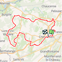
Trail Mountain bike of 40 km to be discovered at Bourgogne-Franche-Comté, Doubs, Chemaudin et Vaux. This trail is proposed by tracegps.

Description

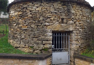
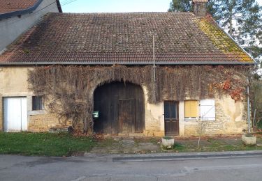
Ce parcours est de niveau moyen - difficile. Il n'y a pas de grosse difficulté, c'est une promenade de village en village. On y roule très souvent sur des chemins blancs qui sont très agréables. Il nous permet de traverser des villages un peu reculés que l'on a pas l'habitude de traverser. Belle balade. Le départ se situe dans le village de Chemaudin, sur le parking de l'école maternelle.

Elevation profile

Photos

Positioning

Country:
France
Region :
Bourgogne-Franche-Comté
Department/Province :
Doubs
Municipality :
Chemaudin et Vaux
Location:
Chemaudin
Start:(UTM)
719162 ; 5234071 (31T) N.

Trails nearby

Trail Walking Serre-les-Sapins - serre les sapins la ménère - Photo
Walking
eltonnermou

Walking

Very easy
(1)
Serre-les-Sapins, Bourgogne-Franche-Comté, Doubs, France
10.4 km | 12.6 km-effort
1h 48min
Yes
Trail On foot Grandfontaine - Sentier de Béthanier-la-Marne - Photo
On foot
PRO

On foot

Easy
Grandfontaine, Bourgogne-Franche-Comté, Doubs, France
8.5 km | 10.2 km-effort
2h 18min
Yes
Trail Mountain bike Audeux - audeux classik 30 - Photo
Mountain bike
nono25170

Mountain bike

Very easy
(2)
Audeux, Bourgogne-Franche-Comté, Doubs, France
29 km | 36 km-effort
1h 15min
Yes
Trail Walking Serre-les-Sapins - serre les sapins via pirey - Photo
Walking
eltonnermou

Walking

Easy
(1)
Serre-les-Sapins, Bourgogne-Franche-Comté, Doubs, France
14 km | 17.7 km-effort
2h 26min
Yes
Trail Walking Placey - Placeý - Photo
Walking
eltonnermou

Walking

Easy
Placey, Bourgogne-Franche-Comté, Doubs, France
13.5 km | 17.4 km-effort
3h 57min
Yes
Trail Mountain bike Montferrand-le-Château - Avanne Avenney - Photo
Mountain bike
isabelle@porgye.com

Mountain bike

Montferrand-le-Château, Bourgogne-Franche-Comté, Doubs, France
14.2 km | 17 km-effort
1h 22min
No
Trail Walking Pouilley-Français - Pouilley Français  - Photo
Walking
eltonnermou

Walking

Easy
Pouilley-Français, Bourgogne-Franche-Comté, Doubs, France
13.3 km | 16.5 km-effort
2h 2min
Yes
Trail Walking Serre-les-Sapins - rando serre pirey  - Photo
Walking
mig26

Walking

Easy
(1)
Serre-les-Sapins, Bourgogne-Franche-Comté, Doubs, France
12.2 km | 15.6 km-effort
3h 14min
Yes
Trail Walking Serre-les-Sapins - Serre les Sapins - Photo
Walking
legios84

Walking

Medium
Serre-les-Sapins, Bourgogne-Franche-Comté, Doubs, France
12.9 km | 16.4 km-effort
2h 46min
Yes


Close
My subscriptions