


Hochsauerringrad

karawatsj
User
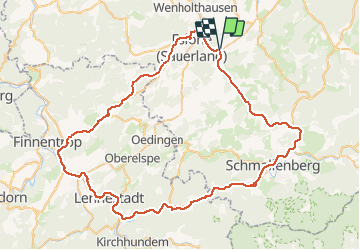

Length
74 km

Max alt
471 m

Uphill gradient
1156 m
Km-Effort
89 km

Min alt
239 m

Downhill gradient
1156 m
Boucle
Yes
Creation date :
2019-01-15 16:10:29.048
Updated on :
2019-01-15 16:10:29.048
4h47
Difficulty : Easy

FREE GPS app for hiking
 SityTrail
IGN / Geographical institutes
SityTrail Plus
The world is yours!
About
Trail Cycle of 74 km to be discovered at North Rhine-Westphalia, Hochsauerlandkreis, Eslohe. This trail is proposed by karawatsj.
Photos


Positioning
Country:
Germany
Region :
North Rhine-Westphalia
Department/Province :
Hochsauerlandkreis
Municipality :
Eslohe
Location:
Unknown
Start:(Dec)
Start:(UTM)
444869 ; 5678127 (32U) N.
Comments