Trail Walking Hondarribia/Fontarrabie - Jaizkibel - Chemin côtier - Cap du Figuier - Notre-Dame de Guadalupe - Photo

Jaizkibel - Chemin côtier - Cap du Figuier - Notre-Dame de Guadalupe

 georgein
georgein

User

© OpenStreetMap contributors
Length
Length
13.7 km
Max alt
Max alt
202 m
Uphill gradient
Uphill gradient
387 m
Km-Effort
Km-Effort  
18.9 km
Min alt
Min alt
5 m
Downhill gradient
Downhill gradient
383 m
Boucle
Boucle
Yes
Creation date :
2019-08-04 09:20:38.267
Updated on :
2020-01-31 20:30:09.353

(3 Reviews)

Walking
Walking
3h59
Difficulty : Unknown

Scan this QR Code to open this trail in the SityTrail application

FREE GPS app for hiking

Logo SityTrail SityTrail

IGN / Geographical institutes

Download SityTrail from the App Store Download SityTrail from Google Play

Logo SityTrail SityTrail World

The world is yours!

Download SityTrail from the App Store Download SityTrail from Google Play Download SityTrail on Huawei AppGallery

About

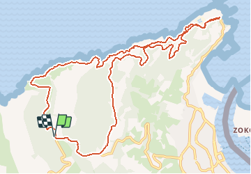
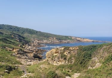
Trail Walking of 13.7 km to be discovered at Autonomous Community of the Basque Country, Gipuzkoa, Hondarribia/Fontarrabie. This trail is proposed by georgein.

Description

La randonnée se situe en partie Nord du Mont Jaizkibel, le chemin longe l'Océan jusqu'au phare du Figuier, un retour par la forêt, Fort et Chapelle de Guadalupe.

Elevation profile

Points of interest

Point of interest Hondarribia/Fontarrabie - Parking après la Chapelle de Guadalupe - Photo
georgein
HONDARRIBIA/FONTARRABIE 
Point of interest Hondarribia/Fontarrabie - Intersection avec le GR121 - Photo
georgein
HONDARRIBIA/FONTARRABIE 
Point of interest Hondarribia/Fontarrabie - Face à une crique - Photo
georgein
HONDARRIBIA/FONTARRABIE 
Point of interest Hondarribia/Fontarrabie - Bâtiment en béton et bassins clôturés - Photo
georgein
HONDARRIBIA/FONTARRABIE 
Point of interest Hondarribia/Fontarrabie - Pont pour franchir un ru - Photo
georgein
HONDARRIBIA/FONTARRABIE 
Point of interest Hondarribia/Fontarrabie - Pont pour traverser le ru - Photo
georgein
HONDARRIBIA/FONTARRABIE 
Point of interest Hondarribia/Fontarrabie - Intersection avec un large chemin - Photo
georgein
HONDARRIBIA/FONTARRABIE 
Point of interest Hondarribia/Fontarrabie - Phare du Figuier et demi tour - Photo
georgein
HONDARRIBIA/FONTARRABIE 
Point of interest Hondarribia/Fontarrabie - Intersection avec un large chemin - Photo
georgein
HONDARRIBIA/FONTARRABIE 
Point of interest Hondarribia/Fontarrabie - Intersection chemin et route goudronnée - Photo
georgein
HONDARRIBIA/FONTARRABIE 
Point of interest Hondarribia/Fontarrabie - Intersection de 4 voies - Photo
georgein
HONDARRIBIA/FONTARRABIE 
Point of interest Hondarribia/Fontarrabie - Panneau indiquant l'entrée du Fort de Guadalupe - Photo
georgein
HONDARRIBIA/FONTARRABIE 
Point of interest Hondarribia/Fontarrabie - Intersection avec un haricot triangulaire - Photo
georgein
HONDARRIBIA/FONTARRABIE 
Point of interest Hondarribia/Fontarrabie - Parking après la Chapelle de Guadalupe - Photo
georgein
HONDARRIBIA/FONTARRABIE 

Positioning

Country:
Spain
Region :
Autonomous Community of the Basque Country
Department/Province :
Gipuzkoa
Municipality :
Hondarribia/Fontarrabie
Location:
Unknown
Start:(UTM)
594546 ; 4802584 (30T) N.

Comments

Please log in to post a review or rate the element


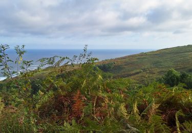
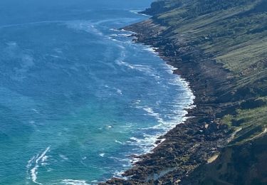
côte basque espagnole magnifique !


Trails nearby

Trail Walking Hondarribia/Fontarrabie - roro - Photo
Walking
chantal40

Walking

Very easy
(1)
Hondarribia/Fontarrabie, Autonomous Community of the Basque Country, Gipuzkoa, Spain
21 km | 31 km-effort
9h 10min
No
Trail Walking Hondarribia/Fontarrabie - Pasaia les vallées des couleurs - Photo
Walking
ChristopheLefauconnier

Walking

Difficult
Hondarribia/Fontarrabie, Autonomous Community of the Basque Country, Gipuzkoa, Spain
11.9 km | 18 km-effort
4h 34min
Yes
Trail Walking Pasaia - Littoral du Jaizkibel I - Photo
Walking
DECHAMPD

Walking

Very difficult
Pasaia, Autonomous Community of the Basque Country, Gipuzkoa, Spain
10.3 km | 18.6 km-effort
3h 42min
Yes
Trail Walking Hondarribia/Fontarrabie - Fondarrabie sentier côtier bis  - Photo
Walking
GUIDE
antignacs

Walking

Easy
Hondarribia/Fontarrabie, Autonomous Community of the Basque Country, Gipuzkoa, Spain
13.1 km | 18 km-effort
3h 56min
Yes
Trail On foot Irun - SL-GI 1006 Cascada de Aitzondo - Photo
On foot
PRO

On foot

Easy
Irun, Autonomous Community of the Basque Country, Gipuzkoa, Spain
6 km | 8.4 km-effort
1h 54min
Yes
Trail Walking Hondarribia/Fontarrabie - hondarribia cap figuier - Photo
Walking
marchev

Walking

Medium
Hondarribia/Fontarrabie, Autonomous Community of the Basque Country, Gipuzkoa, Spain
15.1 km | 21 km-effort
5h 15min
Yes
Trail Walking Pasaia -  Piemont du Jaizkibel  Pays Basque Espagne - Photo
Walking
DECHAMPD

Walking

Very easy
Pasaia, Autonomous Community of the Basque Country, Gipuzkoa, Spain
9.8 km | 15.2 km-effort
7h 21min
Yes
Trail Walking Irun - Ibarla - Cascade d'Aitzondo - Ermitage san Martzial 2020 01 21 - Photo
Walking
DECHAMPD

Walking

Irun, Autonomous Community of the Basque Country, Gipuzkoa, Spain
13 km | 21 km-effort
5h 4min
Yes
Trail Walking Pasaia -  Piemont du Jaizkibel  Pays Basque Espagne - Photo
Walking
DECHAMPD

Walking

Very easy
Pasaia, Autonomous Community of the Basque Country, Gipuzkoa, Spain
9.8 km | 15.2 km-effort
7h 21min
Yes


Close
My subscriptions