


Rocher du corbeau depuis CCAS Aiguebelette

StephaneBM
User
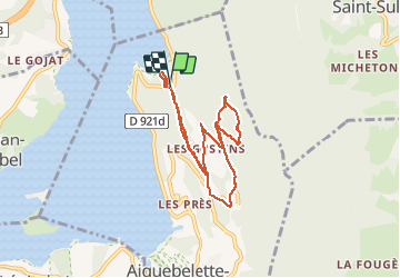

Length
7.9 km

Max alt
779 m

Uphill gradient
384 m
Km-Effort
13 km

Min alt
376 m

Downhill gradient
397 m
Boucle
Yes
Creation date :
2019-01-15 16:19:33.464
Updated on :
2019-01-15 16:19:33.464
1h44
Difficulty : Easy

FREE GPS app for hiking
 SityTrail
IGN / Geographical institutes
SityTrail Plus
The world is yours!
About
Trail Running of 7.9 km to be discovered at Auvergne-Rhône-Alpes, Savoy, Aiguebelette-le-Lac. This trail is proposed by StephaneBM.
Positioning
Country:
France
Region :
Auvergne-Rhône-Alpes
Department/Province :
Savoy
Municipality :
Aiguebelette-le-Lac
Location:
Unknown
Start:(Dec)
Start:(UTM)
719456 ; 5048866 (31T) N.
Comments