


Paulilles - Cap Rederis - 17.4km 500m 5h15 (45mn) - 2018 09 12

Orcal37
User GUIDE
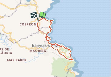

Length
17.4 km

Max alt
150 m

Uphill gradient
468 m
Km-Effort
24 km

Min alt
0 m

Downhill gradient
465 m
Boucle
Yes
Creation date :
2019-01-15 16:27:27.007
Updated on :
2020-01-28 19:39:08.418
5h15
Difficulty : Medium

FREE GPS app for hiking
 SityTrail
IGN / Geographical institutes
SityTrail Plus
The world is yours!
About
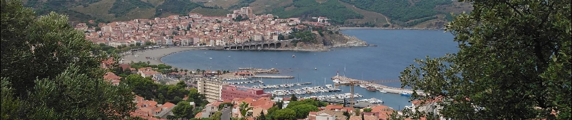
Trail Walking of 17.4 km to be discovered at Occitania, Pyrénées-Orientales, Port-Vendres. This trail is proposed by Orcal37.
Description
Paulilles - Cap Rederis (via Banyuls-sur-Mer) - 17.4km 500m 5h15 (45mn) - 2018 09 12
Photos
 - 2018 09 12 - Photo 1")
 - 2018 09 12 - Photo 2")
 - 2018 09 12 - Photo 3")
 - 2018 09 12 - Photo 4")
 - 2018 09 12 - Photo 5")
 - 2018 09 12 - Photo 6")
 - 2018 09 12 - Photo 7")
 - 2018 09 12 - Photo 8")
 - 2018 09 12 - Photo 9")
 - 2018 09 12 - Photo 10")
 - 2018 09 12 - Photo 11")
 - 2018 09 12 - Photo 12")
 - 2018 09 12 - Photo 13")
 - 2018 09 12 - Photo 14")
 - 2018 09 12 - Photo 15")
 - 2018 09 12 - Photo 16")
 - 2018 09 12 - Photo 17")
 - 2018 09 12 - Photo 18")
 - 2018 09 12 - Photo 19")
 - 2018 09 12 - Photo 20")
 - 2018 09 12 - Photo 21")
 - 2018 09 12 - Photo 22")
 - 2018 09 12 - Photo 23")
 - 2018 09 12 - Photo 24")
 - 2018 09 12 - Photo 25")
 - 2018 09 12 - Photo 26")
 - 2018 09 12 - Photo 27")
 - 2018 09 12 - Photo 28")
 - 2018 09 12 - Photo 29")
 - 2018 09 12 - Photo 30")
 - 2018 09 12 - Photo 31")
 - 2018 09 12 - Photo 32")
 - 2018 09 12 - Photo 33")
 - 2018 09 12 - Photo 34")
 - 2018 09 12 - Photo 35")
 - 2018 09 12 - Photo 36")
 - 2018 09 12 - Photo 37")
 - 2018 09 12 - Photo 38")
 - 2018 09 12 - Photo 39")
 - 2018 09 12 - Photo 40")
 - 2018 09 12 - Photo 41")
 - 2018 09 12 - Photo 42")
 - 2018 09 12 - Photo 43")
 - 2018 09 12 - Photo 44")
 - 2018 09 12 - Photo 45")
 - 2018 09 12 - Photo 46")
 - 2018 09 12 - Photo 47")
 - 2018 09 12 - Photo 48")
 - 2018 09 12 - Photo 49")
 - 2018 09 12 - Photo 50")
50 photos in total. Please click on a photo to see them all in the gallery.
Positioning
Country:
France
Region :
Occitania
Department/Province :
Pyrénées-Orientales
Municipality :
Port-Vendres
Location:
Unknown
Start:(Dec)
Start:(UTM)
509700 ; 4705168 (31T) N.
Comments