Pyrénées-Orientales, Occitania: Best trails, routes and walks

576 comments

Pyrénées-Orientales: Discover the best trails: 4,595 hiking trails, 586 bike and mountain-bike routes and 43 equestrian circuits. All these trails, routes and outdoor activities are available in our SityTrail applications for smartphones and tablets.


The best trails (5701)

Trail Mountain bike Argelès-sur-Mer - la dujardin - Photo
Mountain bike 11.561
Km

Mountain bike

Very easy
(5)
Argelès-sur-Mer, Occitania, Pyrénées-Orientales, France
11.6 km | 18.7 km-effort
1h 11min
530 m
546 m
No
fine66

Trail Walking Port-Vendres - Le sentier des douaniers (Port-Vendres) - Photo
Walking 14.539
Km

Walking

Medium
(5)
Port-Vendres, Occitania, Pyrénées-Orientales, France
14.5 km | 19.1 km-effort
4h 0min
342 m
341 m
Yes
tracegps

Trail Walking Ille-sur-Têt - ILLE TÊT 66 - PIC PEDROUS - CASESNOVES - Photo
Walking 10.965
Km

Walking

Medium
(10)
Ille-sur-Têt, Occitania, Pyrénées-Orientales, France
11 km | 15.3 km-effort
2h 22min
326 m
326 m
Yes
jeff66

Trail Walking Les Cluses - LES CLUSES 66 - Photo
Walking 9.399
Km

Walking

Easy
(9)
Les Cluses, Occitania, Pyrénées-Orientales, France
9.4 km | 12.8 km-effort
1h 50min
257 m
260 m
Yes
jeff66

Trail Walking Collioure - Collioure-le racou - Photo
Walking 7.153
Km

Walking

Medium
(1)
Collioure, Occitania, Pyrénées-Orientales, France
7.2 km | 9.3 km-effort
2h 1min
165 m
162 m
Yes
jeromelacoste

Trail Walking Casteil - rando casteil du cady - Photo
Walking 5.28
Km

Walking

Very easy
(1)
Casteil, Occitania, Pyrénées-Orientales, France
5.3 km | 8.7 km-effort
3h 16min
240 m
314 m
No
attelageplaisir

Trail Walking Tautavel - Tautavel chemin des bacs - Photo
Walking 9.469
Km

Walking

Easy
(3)
Tautavel, Occitania, Pyrénées-Orientales, France
9.5 km | 12.4 km-effort
2h 30min
218 m
218 m
Yes
jcmartin

Trail Walking Sournia - sournia st michel - Photo
Walking 6.982
Km

Walking

Easy
(1)
Sournia, Occitania, Pyrénées-Orientales, France
7 km | 9.3 km-effort
2h 15min
175 m
170 m
Yes
becken

• rando pour famille

Trail Walking Font-Romeu-Odeillo-Via - Coll del Pam lac des  Bouillouses - Photo
Walking 13.325
Km

Walking

Medium
(2)
Font-Romeu-Odeillo-Via, Occitania, Pyrénées-Orientales, France
13.3 km | 19.3 km-effort
4h 10min
447 m
447 m
Yes
jcmartin

• Beau parcours mais attention entre l'Estany Llarg et l'Estany Negre le Gps était éteint mais le sentier est bien bali...

Trail Walking Ur - de Ur vers La Chapelle de Belloc - Photo
Walking 19.964
Km

Walking

Easy
(1)
Ur, Occitania, Pyrénées-Orientales, France
20 km | 28 km-effort
7h 14min
618 m
620 m
Yes
ThonyM

• Une belle randonnée pas difficile

Trail Walking Ria-Sirach - Sirach-Taurinya-Saint Michel de Cuxa - Photo
Walking 13.463
Km

Walking

Easy
(2)
Ria-Sirach, Occitania, Pyrénées-Orientales, France
13.5 km | 17.2 km-effort
2h 31min
283 m
282 m
Yes
ThonyM

• Ballade agréable en parcours ombrage. Aucune difficulté

Trail Walking Vivès - Le sentier de Vinés - Photo
Walking 9.886
Km

Walking

Easy
(2)
Vivès, Occitania, Pyrénées-Orientales, France
9.9 km | 13 km-effort
2h 54min
230 m
231 m
Yes
bernarb

Trail Walking Laroque-des-Albères - 66 LAROQUE DES ALBERES (maison) SOREDE, par pistes DFCI AL12 et 19, mas del Ca et mas Manere, Itin.16  - Photo
Walking 11.236
Km

Walking

Medium
(1)
Laroque-des-Albères, Occitania, Pyrénées-Orientales, France
11.2 km | 15.3 km-effort
2h 5min
303 m
303 m
Yes
jeff66

• 66 LAROQUE DES ALBERES (maison) place des Vernédes, av. du Roussillon, rue de Roca-Vella, mas PEYRE, chapelle St fruc...

Trail Walking Céret - Cretes de Ceret_Fontfrede - Photo
Walking 8.318
Km

Walking

Medium
(2)
Céret, Occitania, Pyrénées-Orientales, France
8.3 km | 14.1 km-effort
3h 14min
437 m
437 m
Yes
force

• site conseil general 66. Belle randonnée en grande partie en sous bois

Trail Walking Nahuja - boucle de Nahuja - Photo
Walking 11.774
Km

Walking

Medium
(1)
Nahuja, Occitania, Pyrénées-Orientales, France
11.8 km | 18.2 km-effort
2h 44min
480 m
484 m
Yes
crijack

• Chemin de Nahuja au refuge et retour avec une vue splendide tout au long de la descente qui se termine par un petit r...

Trail Motor Codalet - Prades - Villefranche de Conflent - Evol  - Photo
Motor 35.809
Km

Motor

Easy
(1)
Codalet, Occitania, Pyrénées-Orientales, France
36 km | 48 km-effort
3h 47min
1013 m
638 m
No
crijack

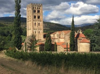
• Route touristique au départ de Ste Marie de Cuxa, direction Font Romeu, arrêt à Villefranche de Conflent pour une pro...

Trail Walking Laroque-des-Albères - 66 SOREDE, LAROQUE DES ALBERES, chemins des Mas - Photo
Walking 6.958
Km

Walking

Medium
(1)
Laroque-des-Albères, Occitania, Pyrénées-Orientales, France
7 km | 8.9 km-effort
1h 22min
149 m
148 m
Yes
jeff66

• 66 SOREDE, mas del Ca, maison de retraite, DFCI AL11, mas d'en Lys, mas Dels Serrallers, mas St Joseph, citerne DFCI ...

Trail Walking Eyne - Eyne,col de Nuria,pic d'Eyne,Torre d'Eyne,Eyne. - Photo
Walking 23.854
Km

Walking

Very difficult
(1)
Eyne, Occitania, Pyrénées-Orientales, France
24 km | 43 km-effort
8h 44min
1437 m
1437 m
Yes
Machaon6

Trail Walking Montescot - 66 VILLENEUVE-DE-LA-RAHO grand tour du lac en Sens horaire  - Photo
Walking 6.735
Km

Walking

Easy
(1)
Montescot, Occitania, Pyrénées-Orientales, France
6.7 km | 7.5 km-effort
1h 4min
60 m
60 m
Yes
jeff66

• 66 VILLENEUVE-DE-LA-RAHO grand tour du lac en Sens horaire

Trail Walking Saint-Jean-Pla-de-Corts - 66 ST-JEAN-PLA-DE-CORTS, promenade autour du Tech, jusqu'au BOULOU  - Photo
Walking 7.939
Km

Walking

Easy
(1)
Saint-Jean-Pla-de-Corts, Occitania, Pyrénées-Orientales, France
7.9 km | 8.8 km-effort
1h 18min
66 m
65 m
Yes
jeff66

• 66 ST-JEAN-PLA-DE-CORTS, domaine ALQUIER, itinéraire cycliste et pédestre vers Le BOULOU, pont sur l'A9, Hortes del B...

20 trails displayed on 5701

FREE GPS app for hiking

Logo SityTrail SityTrail

IGN / Geographical institutes

Download SityTrail from the App Store Download SityTrail from Google Play

Logo SityTrail SityTrail World

The world is yours!

Download SityTrail from the App Store Download SityTrail from Google Play Download SityTrail on Huawei AppGallery

Activities

Nearby regions

Close
My subscriptions