Trail Mountain bike Prayssas - Espace VTT FFC Randonnée entre Lot et Garonne - Circuit n°14 - Coeur de Pays - Photo

Espace VTT FFC Randonnée entre Lot et Garonne - Circuit n°14 - Coeur de Pays

 tracegps
tracegps

User

© OpenStreetMap contributors
Length
Length
36 km
Max alt
Max alt
207 m
Uphill gradient
Uphill gradient
860 m
Km-Effort
Km-Effort  
47 km
Min alt
Min alt
62 m
Downhill gradient
Downhill gradient
862 m
Boucle
Boucle
Yes
Creation date :
2014-12-10 00:00:00.0
Updated on :
2014-12-10 00:00:00.0

(0 Reviews)

Mountain bike
Mountain bike
3h00
Difficulty : Very difficult

Scan this QR Code to open this trail in the SityTrail application

FREE GPS app for hiking

Logo SityTrail SityTrail

IGN / Geographical institutes

Download SityTrail from the App Store Download SityTrail from Google Play

Logo SityTrail SityTrail World

The world is yours!

Download SityTrail from the App Store Download SityTrail from Google Play Download SityTrail on Huawei AppGallery

About

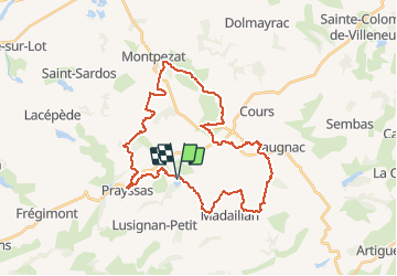
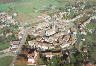
Trail Mountain bike of 36 km to be discovered at New Aquitaine, Lot-et-Garonne, Prayssas. This trail is proposed by tracegps.

Description

Espace VTT FFC Randonnée entre Lot et Garonne - Circuit n°14 - Cœur de Pays. Circuit officiel labellisé par la Fédération Française de Cyclisme. Départ du Lac de Néguenou. L'espace randonnée VTT prend naissance dans la vallée du Lot et s'étend jusque sur les coteaux du "Pays de Serres". Ce circuit très difficile vous fera découvrir et aimer à coup sûr ce territoire, véritable écrin de verdure, ancré dans l'histoire.

Elevation profile

Photos

Positioning

Country:
France
Region :
New Aquitaine
Department/Province :
Lot-et-Garonne
Municipality :
Prayssas
Location:
Unknown
Start:(UTM)
303770 ; 4907315 (31T) N.

Trails nearby

Trail Walking Prayssas - Prayssas, le circuit des pigeonniers - Pays de la vallée du Lot - Photo
Walking
tracegps

Walking

Medium
(3)
Prayssas, New Aquitaine, Lot-et-Garonne, France
12.1 km | 15.9 km-effort
2h 30min
Yes
Trail On foot Prayssas - Prayssas, tourisme au pays du chasselas - 9km - Photo
On foot
PRO

On foot

Easy
Prayssas, New Aquitaine, Lot-et-Garonne, France
9 km | 12.3 km-effort
2h 48min
No
Trail Walking Madaillan - Les pieds dans le ruisseau - Photo
Walking
jpviau

Walking

Very easy
Madaillan, New Aquitaine, Lot-et-Garonne, France
7.2 km | 9.4 km-effort
1h 58min
Yes
Trail Mountain bike Prayssas - Lac de Néguenou à Montpezat - Photo
Mountain bike
tracegps

Mountain bike

Very difficult
Prayssas, New Aquitaine, Lot-et-Garonne, France
43 km | 54 km-effort
4h 0min
Yes
Trail Mountain bike Prayssas - Parcours de Prayssas - Photo
Mountain bike
tracegps

Mountain bike

Very difficult
Prayssas, New Aquitaine, Lot-et-Garonne, France
59 km | 77 km-effort
4h 30min
Yes
Trail Equestrian Prayssas - Prayssas / Quittimont, circuit panoramique dans le Pays de Serres - Pays de la vallée du Lot - Photo
Equestrian
tracegps

Equestrian

Medium
Prayssas, New Aquitaine, Lot-et-Garonne, France
11.9 km | 15.7 km-effort
2h 0min
Yes
Trail Mountain bike Prayssas - Prayssas / Quittimont, circuit panoramique dans le Pays de Serres - Pays de la vallée du Lot - Photo
Mountain bike
tracegps

Mountain bike

Medium
Prayssas, New Aquitaine, Lot-et-Garonne, France
11.9 km | 15.7 km-effort
1h 30min
Yes
Trail Walking Prayssas - Prayssas / Quittimont, circuit panoramique dans le Pays de Serres - Pays de la vallée du Lot - Photo
Walking
tracegps

Walking

Medium
Prayssas, New Aquitaine, Lot-et-Garonne, France
11.9 km | 15.7 km-effort
3h 15min
Yes
Trail Mountain bike Prayssas - Prayssas, le circuit des pigeonniers - Pays de la vallée du Lot - Photo
Mountain bike
tracegps

Mountain bike

Medium
Prayssas, New Aquitaine, Lot-et-Garonne, France
12.1 km | 15.9 km-effort
1h 10min
Yes


Close
My subscriptions