Trail Walking Villard-Reymond - Malraux Croix du Carrelet - Photo
 rapako
rapako

User

© OpenStreetMap contributors
Length
Length
9.3 km
Max alt
Max alt
2189 m
Uphill gradient
Uphill gradient
604 m
Km-Effort
Km-Effort  
17.4 km
Min alt
Min alt
1608 m
Downhill gradient
Downhill gradient
621 m
Boucle
Boucle
Yes
Creation date :
2019-01-15 16:29:55.466
Updated on :
2019-07-14 15:30:06.731

(0 Reviews)

Walking
Walking
3h29
Difficulty : Unknown

Scan this QR Code to open this trail in the SityTrail application

FREE GPS app for hiking

Logo SityTrail SityTrail

IGN / Geographical institutes

Download SityTrail from the App Store Download SityTrail from Google Play

Logo SityTrail SityTrail World

The world is yours!

Download SityTrail from the App Store Download SityTrail from Google Play Download SityTrail on Huawei AppGallery

About

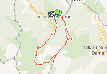
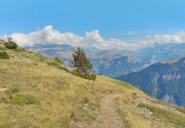
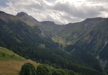
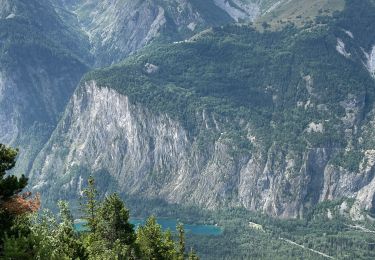
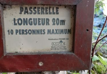
Trail Walking of 9.3 km to be discovered at Auvergne-Rhône-Alpes, Isère, Villard-Reymond. This trail is proposed by rapako.

Description

CSC MALRAUX 2018-09-18

Elevation profile

Photos

Positioning

Country:
France
Region :
Auvergne-Rhône-Alpes
Department/Province :
Isère
Municipality :
Villard-Reymond
Location:
Unknown
Start:(UTM)
265140 ; 4990840 (32T) N.

Trails nearby

Trail Walking Le Bourg-d'Oisans - Lac de Buclet et cascade de la Pisse - Photo
Walking
crocau

Walking

Very easy
Le Bourg-d'Oisans, Auvergne-Rhône-Alpes, Isère, France
8.4 km | 10 km-effort
2h 44min
Yes
Trail Walking Les Deux Alpes - lac du Lauvitel - Photo
Walking
chuck

Walking

Difficult
Les Deux Alpes, Auvergne-Rhône-Alpes, Isère, France
8.4 km | 16.7 km-effort
4h 55min
Yes
Trail Walking Ornon - Plateau des lacs - Photo
Walking
ezorzet

Walking

Difficult
Ornon, Auvergne-Rhône-Alpes, Isère, France
15.8 km | 27 km-effort
7h 19min
Yes
Trail Walking Villard-Reymond - La Croix du Carrelet et la crête de Croix de La Garde - Photo
Walking
patjobou

Walking

Medium
Villard-Reymond, Auvergne-Rhône-Alpes, Isère, France
9.9 km | 18.2 km-effort
5h 38min
No
Trail Walking Auris - Auris en Oizan- balade vers Placet - Photo
Walking
laetyan

Walking

Medium
Auris, Auvergne-Rhône-Alpes, Isère, France
5.9 km | 9.6 km-effort
1h 44min
Yes
Trail Walking Le Bourg-d'Oisans - Bourg d'Oisans les cascades - Photo
Walking
cousam

Walking

Difficult
Le Bourg-d'Oisans, Auvergne-Rhône-Alpes, Isère, France
19.1 km | 37 km-effort
9h 0min
Yes
Trail Walking Le Bourg-d'Oisans - 38 BG d Oisans cascade pisse - Photo
Walking
himba26100

Walking

Difficult
Le Bourg-d'Oisans, Auvergne-Rhône-Alpes, Isère, France
18.4 km | 36 km-effort
9h 9min
Yes
Trail Touring skiing Ornon - Le Taillefer - Photo
Touring skiing
nadd73

Touring skiing

Medium
Ornon, Auvergne-Rhône-Alpes, Isère, France
19.2 km | 40 km-effort
8h 35min
Yes
Trail Touring skiing Oulles - Le Grand Galbert - Photo
Touring skiing
nadd73

Touring skiing

Medium
Oulles, Auvergne-Rhône-Alpes, Isère, France
10.2 km | 25 km-effort
5h 7min
Yes


Close
My subscriptions