Trail Mountain bike Prades - Grande Traversée VTT FFC Ariège Pyrénées - Etape 2 - Refuge de la Chioula - Comus - Photo

Grande Traversée VTT FFC Ariège Pyrénées - Etape 2 - Refuge de la Chioula - Comus

 tracegps
tracegps

User

© OpenStreetMap contributors
Length
Length
17.5 km
Max alt
Max alt
1674 m
Uphill gradient
Uphill gradient
351 m
Km-Effort
Km-Effort  
24 km
Min alt
Min alt
1164 m
Downhill gradient
Downhill gradient
798 m
Boucle
Boucle
No
Creation date :
2014-12-10 00:00:00.0
Updated on :
2014-12-10 00:00:00.0

(0 Reviews)

Mountain bike
Mountain bike
2h00
Difficulty : Difficult

Scan this QR Code to open this trail in the SityTrail application

FREE GPS app for hiking

Logo SityTrail SityTrail

IGN / Geographical institutes

Download SityTrail from the App Store Download SityTrail from Google Play

Logo SityTrail SityTrail World

The world is yours!

Download SityTrail from the App Store Download SityTrail from Google Play Download SityTrail on Huawei AppGallery

About

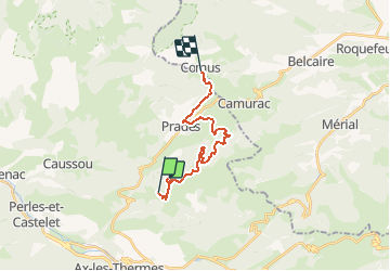
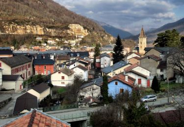
Trail Mountain bike of 17.5 km to be discovered at Occitania, Ariège, Prades. This trail is proposed by tracegps.

Description

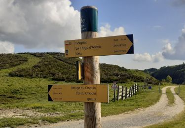
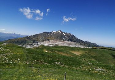
Grande Traversée VTT Ariège Pyrénées - Etape 2 - Refuge de la Chioula – Comus. Circuit labellisé par la Fédération Française de Cyclisme. Deuxième étape parfois difficile techniquement, mais moins physique que la précédente. De magnifiques panoramas sur le massif avant une bonne descente sur Montailloux et son château. Agence de Développement Touristique d'Ariège Pyrénées Route de Ganac – BP 30143 – 09004 Foix Cedex Tél : 05 61 02 30 70/fax : 05 61 65 17 34

Elevation profile

Photos

Positioning

Country:
France
Region :
Occitania
Department/Province :
Ariège
Municipality :
Prades
Location:
Unknown
Start:(UTM)
406989 ; 4734245 (31T) N.

Trails nearby

Trail Walking Sorgeat - Chemin des Bonhommes - Sorgeat Merens - Photo
Walking
tracegps

Walking

Very difficult
(1)
Sorgeat, Occitania, Ariège, France
21 km | 36 km-effort
8h 0min
No
Trail Walking Ax-les-Thermes - Lac de Campauleil - Orgeix - Photo
Walking
Oupia82

Walking

Very easy
(1)
Ax-les-Thermes, Occitania, Ariège, France
8.6 km | 11.2 km-effort
3h 3min
Yes
Trail Walking Ignaux - Chioula d - Photo
Walking
GUIDE
antignacs

Walking

Very easy
Ignaux, Occitania, Ariège, France
15.1 km | 21 km-effort
3h 50min
Yes
Trail Walking Prades - La Chioula Orlu GR107 le chemins des Bonshommes - Photo
Walking
tercla

Walking

Difficult
Prades, Occitania, Ariège, France
18.7 km | 25 km-effort
6h 17min
No
Trail Walking Ax-les-Thermes - balade bleue au dessus d'Ax - Photo
Walking
c.chehere

Walking

Easy
Ax-les-Thermes, Occitania, Ariège, France
3.8 km | 6.1 km-effort
1h 22min
Yes
Trail Walking Ax-les-Thermes - Orgeix _ Ignaux - Photo
Walking
c.chehere

Walking

Medium
Ax-les-Thermes, Occitania, Ariège, France
12.8 km | 19.1 km-effort
4h 12min
Yes
Trail Walking Caussou - Le col de Marmare - Photo
Walking
c.chehere

Walking

Medium
Caussou, Occitania, Ariège, France
14.1 km | 21 km-effort
4h 21min
Yes
Trail Walking Prades - Pic Fourcat Prades  - Photo
Walking
caccini

Walking

Medium
(1)
Prades, Occitania, Ariège, France
14 km | 25 km-effort
6h 52min
Yes
Trail On foot Ax-les-Thermes - GRP Ax-Orgeix - Photo
On foot
PRO

On foot

Easy
Ax-les-Thermes, Occitania, Ariège, France
4 km | 5.7 km-effort
1h 17min
No


Close
My subscriptions