Trail Mountain bike Montégut-Plantaurel - Grande Traversée VTT FFC Arièges Pyrénées - Etape 9 - Montégut Plantaurel - Le Mas d'Azil - Photo

Grande Traversée VTT FFC Arièges Pyrénées - Etape 9 - Montégut Plantaurel - Le Mas d'Azil

 tracegps
tracegps

User

© OpenStreetMap contributors
Length
Length
23 km
Max alt
Max alt
533 m
Uphill gradient
Uphill gradient
698 m
Km-Effort
Km-Effort  
33 km
Min alt
Min alt
279 m
Downhill gradient
Downhill gradient
800 m
Boucle
Boucle
No
Creation date :
2014-12-10 00:00:00.0
Updated on :
2023-05-08 08:29:38.813

(0 Reviews)

Mountain bike
Mountain bike
2h30
Difficulty : Difficult

Scan this QR Code to open this trail in the SityTrail application

FREE GPS app for hiking

Logo SityTrail SityTrail

IGN / Geographical institutes

Download SityTrail from the App Store Download SityTrail from Google Play

Logo SityTrail SityTrail World

The world is yours!

Download SityTrail from the App Store Download SityTrail from Google Play Download SityTrail on Huawei AppGallery

About

Trail Mountain bike of 23 km to be discovered at Occitania, Ariège, Montégut-Plantaurel. This trail is proposed by tracegps.

Description

Grande Traversée VTT Ariège Pyrénées - Étape 9 - Montégut Plantaurel - Mas d'Azil. Circuit labellisé par la Fédération Française de Cyclisme. Une étape sportive avec plusieurs singletracks costauds. Agence de Développement Touristique d'Ariège Pyrénées Route de Ganac – BP 30143 – 09004 Foix Cedex Tél : 05 61 02 30 70/fax : 05 61 65 17 34

Elevation profile

Positioning

Country:
France
Region :
Occitania
Department/Province :
Ariège
Municipality :
Montégut-Plantaurel
Location:
Unknown
Start:(UTM)
378022 ; 4769388 (31T) N.

Trails nearby

Trail Equestrian Baulou - Cadarcet - La Bastide-de-Sérou - Photo
Equestrian
tracegps

Equestrian

Medium
Baulou, Occitania, Ariège, France
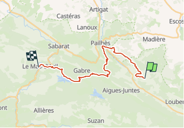
9.2 km | 11.4 km-effort
1h 0min
No
Trail Equestrian Pailhès - Chemin de St Jacques -Pailhès - Rioutaillol - Photo
Equestrian
tracegps

Equestrian

Difficult
Pailhès, Occitania, Ariège, France
8.3 km | 12.3 km-effort
1h 0min
No
Trail Equestrian Montégut-Plantaurel - Chemin de St Jacques -Montaigut Plantaurel - Pailhès - Photo
Equestrian
tracegps

Equestrian

Difficult
Montégut-Plantaurel, Occitania, Ariège, France
8.5 km | 12.2 km-effort
1h 0min
No
Trail Walking Montégut-Plantaurel - Chemin du Piémont Pyrénéen - du château de la Hille à la Grausse - Photo
Walking
tracegps

Walking

Difficult
Montégut-Plantaurel, Occitania, Ariège, France
26 km | 34 km-effort
6h 0min
No
Trail Walking Saint-Victor-Rouzaud - GR78 - Etape 5bis Saint Victor Rouzaud - Caoué de coume - Photo
Walking
patoche2009

Walking

Medium
Saint-Victor-Rouzaud, Occitania, Ariège, France
37 km | 51 km-effort
10h 36min
No
Trail Walking Montégut-Plantaurel - GR78 - Etape 5 Sabarthèe - Caoué de coume - Photo
Walking
patoche2009

Walking

Medium
Montégut-Plantaurel, Occitania, Ariège, France
30 km | 41 km-effort
7h 32min
No
Trail Walking Pailhès - Pailhes-Le Mas - Photo
Walking
DEDIEUJ

Walking

Medium
Pailhès, Occitania, Ariège, France
15.3 km | 21 km-effort
4h 30min
No
Trail Cycle Loubens - loubens foix st girons fois - Photo
Cycle
Maca8284

Cycle

Difficult
Loubens, Occitania, Ariège, France
103 km | 122 km-effort
7h 43min
Yes
Trail Walking Cadarcet - Plaisance, Terrefort - Photo
Walking
Jean-Paul Raton

Walking

Easy
Cadarcet, Occitania, Ariège, France
4.5 km | 5.9 km-effort
1h 19min
Yes


Close
My subscriptions