Trail Walking Montégut-Plantaurel - Chemin du Piémont Pyrénéen - du château de la Hille à la Grausse - Photo

Chemin du Piémont Pyrénéen - du château de la Hille à la Grausse

 tracegps
tracegps

User

© OpenStreetMap contributors
Length
Length
26 km
Max alt
Max alt
518 m
Uphill gradient
Uphill gradient
631 m
Km-Effort
Km-Effort  
34 km
Min alt
Min alt
279 m
Downhill gradient
Downhill gradient
570 m
Boucle
Boucle
No
Creation date :
2014-12-10 00:00:00.0
Updated on :
2014-12-10 00:00:00.0

(0 Reviews)

Walking
Walking
6h00
Difficulty : Difficult

Scan this QR Code to open this trail in the SityTrail application

FREE GPS app for hiking

Logo SityTrail SityTrail

IGN / Geographical institutes

Download SityTrail from the App Store Download SityTrail from Google Play

Logo SityTrail SityTrail World

The world is yours!

Download SityTrail from the App Store Download SityTrail from Google Play Download SityTrail on Huawei AppGallery

About

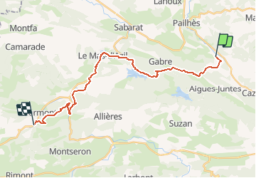
Trail Walking of 26 km to be discovered at Occitania, Ariège, Montégut-Plantaurel. This trail is proposed by tracegps.

Description

A partir de la Hillette, rejoindre Couronne, suivre la D131, passer le pas du roc, tourner à droite sur la D1, avant le Pontet prendre à droite direction Montauriol, descendre vers le lac fillet, rejoindre la D1, la prendre à droite, traverser l'Arise, rejoindre le mas d'Azil, traverser la grotte,quitter la route en direction de la Plagne,Coué, suivre en lisière de forêt jusqu'au pont prêt de la ferme Camp Bataille, suivre la route à droite pendant 1 km, prende un sentier à droite, traverser Capes,Baluet,Cap del Pradou,descendre sur la Grausse

Elevation profile

Photos

Positioning

Country:
France
Region :
Occitania
Department/Province :
Ariège
Municipality :
Montégut-Plantaurel
Location:
Unknown
Start:(UTM)
375553 ; 4770655 (31T) N.

Trails nearby

Trail Equestrian Gabre - Chemin de St Jacques - Rioutaillol - Mondely - Photo
Equestrian
tracegps

Equestrian

Medium
Gabre, Occitania, Ariège, France
4.6 km | 6.6 km-effort
30min
No
Trail Equestrian Pailhès - Chemin de St Jacques -Pailhès - Rioutaillol - Photo
Equestrian
tracegps

Equestrian

Difficult
Pailhès, Occitania, Ariège, France
8.3 km | 12.3 km-effort
1h 0min
No
Trail Equestrian Montégut-Plantaurel - Chemin de St Jacques -Montaigut Plantaurel - Pailhès - Photo
Equestrian
tracegps

Equestrian

Difficult
Montégut-Plantaurel, Occitania, Ariège, France
8.5 km | 12.2 km-effort
1h 0min
No
Trail Walking Gabre - Compos.Gabre-Maneyre 6 - Photo
Walking
ColetteDocteur

Walking

Very difficult
Gabre, Occitania, Ariège, France
19.6 km | 26 km-effort
5h 56min
No
Trail Walking Montégut-Plantaurel - GR78 - Etape 5 Sabarthèe - Caoué de coume - Photo
Walking
patoche2009

Walking

Medium
Montégut-Plantaurel, Occitania, Ariège, France
30 km | 41 km-effort
7h 32min
No
Trail Walking Pailhès - Pailhes-Le Mas - Photo
Walking
DEDIEUJ

Walking

Medium
Pailhès, Occitania, Ariège, France
15.3 km | 21 km-effort
4h 30min
No
Trail Mountain bike Montégut-Plantaurel - Grande Traversée VTT FFC Arièges Pyrénées - Etape 9 - Montégut Plantaurel - Le Mas d'Azil - Photo
Mountain bike
tracegps

Mountain bike

Difficult
Montégut-Plantaurel, Occitania, Ariège, France
23 km | 33 km-effort
2h 30min
No
Trail Walking Gabre - lac de Mondely au lac de feillet par terre rouge,Pastegras, Montouriol , Courtalas et terre rouge - Photo
Walking
Jean-Paul Raton

Walking

Medium
Gabre, Occitania, Ariège, France
5.7 km | 8 km-effort
1h 49min
Yes
Trail Walking Gabre - Terre rouge - Photo
Walking
Jean-Paul Raton

Walking

Medium
Gabre, Occitania, Ariège, France
8.2 km | 10.9 km-effort
2h 28min
Yes


Close
My subscriptions