Trail Walking Angles-sur-l'Anglin - Val d'Angles - Photo
 tracegps
tracegps

User

© OpenStreetMap contributors
Length
Length
10.2 km
Max alt
Max alt
118 m
Uphill gradient
Uphill gradient
163 m
Km-Effort
Km-Effort  
12.3 km
Min alt
Min alt
66 m
Downhill gradient
Downhill gradient
164 m
Boucle
Boucle
Yes
Creation date :
2014-12-10 00:00:00.0
Updated on :
2014-12-10 00:00:00.0

(0 Reviews)

Walking
Walking
2h30
Difficulty : Medium

Scan this QR Code to open this trail in the SityTrail application

FREE GPS app for hiking

Logo SityTrail SityTrail

IGN / Geographical institutes

Download SityTrail from the App Store Download SityTrail from Google Play

Logo SityTrail SityTrail World

The world is yours!

Download SityTrail from the App Store Download SityTrail from Google Play Download SityTrail on Huawei AppGallery

About

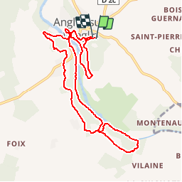
Trail Walking of 10.2 km to be discovered at New Aquitaine, Vienne, Angles-sur-l'Anglin. This trail is proposed by tracegps.

Description

Balade autour d'Angles/Anglin et de son château...

Elevation profile

Photos

Positioning

Country:
France
Region :
New Aquitaine
Department/Province :
Vienne
Municipality :
Angles-sur-l'Anglin
Location:
Unknown
Start:(UTM)
338541 ; 5173297 (31T) N.

Trails nearby

Trail Walking Angles-sur-l'Anglin - Val d'Angles Carrière à sarcophages - Photo
Walking
pirt3

Walking

Medium
(1)
Angles-sur-l'Anglin, New Aquitaine, Vienne, France
7.9 km | 9.7 km-effort
2h 3min
Yes
Trail Walking Angles-sur-l'Anglin - Angles sur l’anglin-1 - Photo
Walking
mclafarie

Walking

Medium
Angles-sur-l'Anglin, New Aquitaine, Vienne, France
10.4 km | 11.8 km-effort
2h 59min
Yes
Trail Walking Angles-sur-l'Anglin - Angles-sur-l'Anglin - 10.2km 200m 3h00 - 2017 05 21 - Photo
Walking
Orcal37

Walking

Easy
Angles-sur-l'Anglin, New Aquitaine, Vienne, France
10.2 km | 12.8 km-effort
3h 0min
Yes
Trail Walking Angles-sur-l'Anglin - Remerle, Angles-sur-l'Anglin - Photo
Walking
jfcousty

Walking

Medium
Angles-sur-l'Anglin, New Aquitaine, Vienne, France
5.6 km | 6.8 km-effort
1h 32min
Yes
Trail Walking Vicq-sur-Gartempe - Vicq Montin La Chataigneraie - Photo
Walking
ehalle8544

Walking

Easy
Vicq-sur-Gartempe, New Aquitaine, Vienne, France
4.1 km | 5 km-effort
1h 5min
Yes
Trail Mountain bike Vicq-sur-Gartempe - Zevtt - Vic sur Gartempe 54km - Photo
Mountain bike
kipoura

Mountain bike

Medium
Vicq-sur-Gartempe, New Aquitaine, Vienne, France
54 km | 64 km-effort
3h 0min
Yes
Trail Mountain bike Vicq-sur-Gartempe - Zevtt - Vic sur Gartempe 53km - Photo
Mountain bike
kipoura

Mountain bike

Medium
Vicq-sur-Gartempe, New Aquitaine, Vienne, France
53 km | 63 km-effort
3h 10min
No
Trail Walking Angles-sur-l'Anglin - 15000 ans d'histoire - Angles sur Anglin - Photo
Walking
tracegps

Walking

Medium
Angles-sur-l'Anglin, New Aquitaine, Vienne, France
12.7 km | 14.6 km-effort
3h 30min
Yes
Trail Horseback riding Saint-Pierre-de-Maillé - Saint Pierre de Maillé 24km - Photo
Horseback riding
Dom4i

Horseback riding

Medium
Saint-Pierre-de-Maillé, New Aquitaine, Vienne, France
24 km | 28 km-effort
3h 59min
No


Close
My subscriptions