Trail Walking Hermaville -  Hermaville - Berles Monchel - Tilloy les Hermavile - Photo

Hermaville - Berles Monchel - Tilloy les Hermavile

 tracegps
tracegps

User

© OpenStreetMap contributors
Length
Length
10 km
Max alt
Max alt
137 m
Uphill gradient
Uphill gradient
98 m
Km-Effort
Km-Effort  
11.3 km
Min alt
Min alt
96 m
Downhill gradient
Downhill gradient
98 m
Boucle
Boucle
Yes
Creation date :
2014-12-10 00:00:00.0
Updated on :
2014-12-10 00:00:00.0

(0 Reviews)

Walking
Walking
2h00
Difficulty : Medium

Scan this QR Code to open this trail in the SityTrail application

FREE GPS app for hiking

Logo SityTrail SityTrail

IGN / Geographical institutes

Download SityTrail from the App Store Download SityTrail from Google Play

Logo SityTrail SityTrail World

The world is yours!

Download SityTrail from the App Store Download SityTrail from Google Play Download SityTrail on Huawei AppGallery

About

Trail Walking of 10 km to be discovered at Hauts-de-France, Pas-de-Calais, Hermaville. This trail is proposed by tracegps.

Description

Randonnée au départ de Hermaville qui passe par Berles-Monchel, Tilloy les Hermaville.

Elevation profile

Photos

Positioning

Country:
France
Region :
Hauts-de-France
Department/Province :
Pas-de-Calais
Municipality :
Hermaville
Location:
Unknown
Start:(UTM)
470337 ; 5574678 (31U) N.

Trails nearby

Trail Walking Hermaville - Chemin de la vertu bleue (Hermanville) - Photo
Walking
tracegps

Walking

Medium
Hermaville, Hauts-de-France, Pas-de-Calais, France
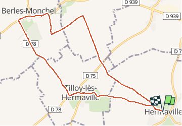
11.1 km | 12.9 km-effort
2h 49min
Yes
Trail Walking Hermaville - Circuit des porches - Hermaville - Photo
Walking
tracegps

Walking

Easy
Hermaville, Hauts-de-France, Pas-de-Calais, France
1.9 km | 2.1 km-effort
1h 0min
Yes
Trail Walking Haute-Avesnes - Haute Avesnes - Hermaville - Photo
Walking
tracegps

Walking

Medium
Haute-Avesnes, Hauts-de-France, Pas-de-Calais, France
9.6 km | 10.9 km-effort
2h 0min
Yes
Trail Walking Hermaville - Hermaville - Izel le Hameau - Tilloy les Hermaville - Photo
Walking
tracegps

Walking

Medium
Hermaville, Hauts-de-France, Pas-de-Calais, France
10.7 km | 11.7 km-effort
2h 30min
Yes
Trail Walking Montenescourt - Montenescourt - Gouves - Wanquetin - Photo
Walking
tracegps

Walking

Medium
Montenescourt, Hauts-de-France, Pas-de-Calais, France
10.6 km | 11.9 km-effort
2h 0min
Yes
Trail Walking Habarcq - Habarcq - Hermaville - Noyelette en l'eau - Photo
Walking
tracegps

Walking

Medium
Habarcq, Hauts-de-France, Pas-de-Calais, France
8.9 km | 10.2 km-effort
2h 0min
Yes
Trail Walking Montenescourt - Montenescourt Habarcq Hermaville Bois d'Habarcq - Photo
Walking
tracegps

Walking

Medium
Montenescourt, Hauts-de-France, Pas-de-Calais, France
11 km | 12.9 km-effort
2h 0min
Yes
Trail Walking Montenescourt - Montenescourt - Wanquetin - Noyellette - Habarcq - Gouves - Photo
Walking
tracegps

Walking

Medium
Montenescourt, Hauts-de-France, Pas-de-Calais, France
10.1 km | 11.2 km-effort
2h 0min
Yes
Trail Walking Hermaville - 62 - Hermaville Izel lez hameau Tilloy les Hermaville - Photo
Walking
tracegps

Walking

Medium
Hermaville, Hauts-de-France, Pas-de-Calais, France
10.4 km | 11.4 km-effort
2h 0min
Yes


Close
My subscriptions