Trail Walking Hermaville - Circuit des porches - Hermaville - Photo

Circuit des porches - Hermaville

 tracegps
tracegps

User

© OpenStreetMap contributors
Length
Length
1.9 km
Max alt
Max alt
106 m
Uphill gradient
Uphill gradient
16 m
Km-Effort
Km-Effort  
2.1 km
Min alt
Min alt
93 m
Downhill gradient
Downhill gradient
18 m
Boucle
Boucle
Yes
Creation date :
2014-12-10 00:00:00.0
Updated on :
2014-12-10 00:00:00.0

(0 Reviews)

Walking
Walking
1h00
Difficulty : Easy

Scan this QR Code to open this trail in the SityTrail application

FREE GPS app for hiking

Logo SityTrail SityTrail

IGN / Geographical institutes

Download SityTrail from the App Store Download SityTrail from Google Play

Logo SityTrail SityTrail World

The world is yours!

Download SityTrail from the App Store Download SityTrail from Google Play Download SityTrail on Huawei AppGallery

About

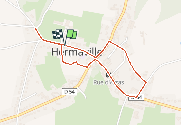
Trail Walking of 1.9 km to be discovered at Hauts-de-France, Pas-de-Calais, Hermaville. This trail is proposed by tracegps.

Description

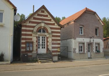
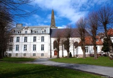
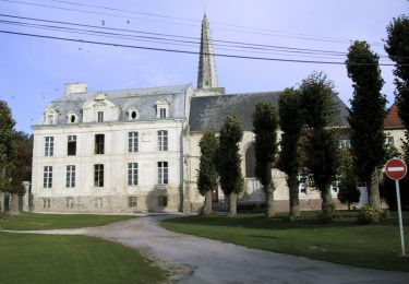
Circuit proposé par Dominique Linard et Jean-Michel Delattre. Ce circuit permet de découvrir le village et ses porches. La plupart des fermes du village sont des fermes à cour fermée. Un panneau posé face à la mairie donne le plan pour partir à la découverte des porches de la commune. Au pied de chaque porche, un descriptif permet de comprendre l'histoire. Départ de la mairie d'Hermaville.

Elevation profile

Photos

Positioning

Country:
France
Region :
Hauts-de-France
Department/Province :
Pas-de-Calais
Municipality :
Hermaville
Location:
Unknown
Start:(UTM)
470284 ; 5574703 (31U) N.

Trails nearby

Trail Walking Hermaville - Chemin de la vertu bleue (Hermanville) - Photo
Walking
tracegps

Walking

Medium
Hermaville, Hauts-de-France, Pas-de-Calais, France
11.1 km | 12.9 km-effort
2h 49min
Yes
Trail Walking Haute-Avesnes - Haute Avesnes - Hermaville - Photo
Walking
tracegps

Walking

Medium
Haute-Avesnes, Hauts-de-France, Pas-de-Calais, France
9.6 km | 10.9 km-effort
2h 0min
Yes
Trail Walking Hermaville - Hermaville - Izel le Hameau - Tilloy les Hermaville - Photo
Walking
tracegps

Walking

Medium
Hermaville, Hauts-de-France, Pas-de-Calais, France
10.7 km | 11.7 km-effort
2h 30min
Yes
Trail Walking Montenescourt - Montenescourt - Gouves - Wanquetin - Photo
Walking
tracegps

Walking

Medium
Montenescourt, Hauts-de-France, Pas-de-Calais, France
10.6 km | 11.9 km-effort
2h 0min
Yes
Trail Walking Hermaville -  Hermaville - Berles Monchel - Tilloy les Hermavile - Photo
Walking
tracegps

Walking

Medium
Hermaville, Hauts-de-France, Pas-de-Calais, France
10 km | 11.3 km-effort
2h 0min
Yes
Trail Walking Habarcq - Habarcq - Hermaville - Noyelette en l'eau - Photo
Walking
tracegps

Walking

Medium
Habarcq, Hauts-de-France, Pas-de-Calais, France
8.9 km | 10.2 km-effort
2h 0min
Yes
Trail Walking Montenescourt - Montenescourt Habarcq Hermaville Bois d'Habarcq - Photo
Walking
tracegps

Walking

Medium
Montenescourt, Hauts-de-France, Pas-de-Calais, France
11 km | 12.9 km-effort
2h 0min
Yes
Trail Walking Montenescourt - Montenescourt - Wanquetin - Noyellette - Habarcq - Gouves - Photo
Walking
tracegps

Walking

Medium
Montenescourt, Hauts-de-France, Pas-de-Calais, France
10.1 km | 11.2 km-effort
2h 0min
Yes
Trail Walking Hermaville - 62 - Hermaville Izel lez hameau Tilloy les Hermaville - Photo
Walking
tracegps

Walking

Medium
Hermaville, Hauts-de-France, Pas-de-Calais, France
10.4 km | 11.4 km-effort
2h 0min
Yes


Close
My subscriptions