Trail Mountain bike Alençon - Médavy, Croix Madame, Chêne aux Verdiers, Saint Nicolas, Colombiers - Photo

Médavy, Croix Madame, Chêne aux Verdiers, Saint Nicolas, Colombiers

 tracegps
tracegps

User

© OpenStreetMap contributors
Length
Length
33 km
Max alt
Max alt
425 m
Uphill gradient
Uphill gradient
400 m
Km-Effort
Km-Effort  
38 km
Min alt
Min alt
141 m
Downhill gradient
Downhill gradient
402 m
Boucle
Boucle
Yes
Creation date :
2014-12-10 00:00:00.0
Updated on :
2014-12-10 00:00:00.0

(0 Reviews)

Mountain bike
Mountain bike
2h10
Difficulty : Medium

Scan this QR Code to open this trail in the SityTrail application

FREE GPS app for hiking

Logo SityTrail SityTrail

IGN / Geographical institutes

Download SityTrail from the App Store Download SityTrail from Google Play

Logo SityTrail SityTrail World

The world is yours!

Download SityTrail from the App Store Download SityTrail from Google Play Download SityTrail on Huawei AppGallery

About

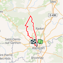
Trail Mountain bike of 33 km to be discovered at Normandy, Orne, Alençon. This trail is proposed by tracegps.

Description

Cette boucle sans grandes difficultés vous propose un tour passant par les grands carrefours de la forêt d'Ecouves. Boucle effectuée mi Janvier juste après les très grosses chutes de neige. Forêt magnifique recouverte d'un manteau de 30cm de neige au moins. Pilotage sur neige très marrant avec risque de belles boîtes si on ne fait pas assez attention. Sans la neige, bon entraînement quand même, en parcourant cette boucle à bon rythme.

Elevation profile

Positioning

Country:
France
Region :
Normandy
Department/Province :
Orne
Municipality :
Alençon
Location:
Unknown
Start:(UTM)
284279 ; 5368719 (31U) N.

Trails nearby

Trail Walking Arçonnay - Arconnay - Photo
Walking
jackls

Walking

Medium
(1)
Arçonnay, Pays de la Loire, Sarthe, France
25 km | 28 km-effort
5h 28min
Yes
Trail Mountain bike Alençon - Montée à la croix de Médavy par route et descente par GR et chemins - Photo
Mountain bike
tracegps

Mountain bike

Easy
(1)
Alençon, Normandy, Orne, France
33 km | 40 km-effort
1h 34min
Yes
Trail Cycle Alençon - Véloscénie 3ème étape  - Photo
Cycle
destras

Cycle

Easy
Alençon, Normandy, Orne, France
116 km | 133 km-effort
7h 29min
No
Trail Mountain bike Saint-Germain-du-Corbéis - Le bois  de vaux - Photo
Mountain bike
yvesportier

Mountain bike

Medium
(2)
Saint-Germain-du-Corbéis, Normandy, Orne, France
35 km | 39 km-effort
2h 16min
Yes
Trail Mountain bike Saint-Germain-du-Corbéis - chapelle St Evroult/château de Vaux - Photo
Mountain bike
yvesportier

Mountain bike

Medium
(1)
Saint-Germain-du-Corbéis, Normandy, Orne, France
34 km | 39 km-effort
2h 8min
Yes
Trail Cycle Alençon - Alençon, Héloup, Gesnes le Gandelin, Arçonnay, Alençon - Photo
Cycle
tracegps

Cycle

Medium
Alençon, Normandy, Orne, France
30 km | 33 km-effort
1h 10min
Yes
Trail Bicycle tourism Alençon - La véloscénie - Alencon - Madré - Tronçon 1 - Photo
Bicycle tourism
GUIDE
jeanmarcMasson

Bicycle tourism

Very difficult
Alençon, Normandy, Orne, France
40 km | 45 km-effort
Unknown
No
Trail Bicycle tourism Alençon - Activity - Photo
Bicycle tourism
GUIDE
jeanmarcMasson

Bicycle tourism

Very difficult
Alençon, Normandy, Orne, France
155 km | 173 km-effort
Unknown
No
Trail Walking Saint-Paterne - Le Chevain - brullemail - Photo
Walking
Béa57

Walking

Very difficult
Saint-Paterne - Le Chevain, Pays de la Loire, Sarthe, France
40 km | 46 km-effort
4h 24min
No


Close
My subscriptions