Trail Mountain bike Cognin - Autour du Corbeley - Photo
 baudrine
baudrine

User

© OpenStreetMap contributors
Length
Length
25 km
Max alt
Max alt
1242 m
Uphill gradient
Uphill gradient
995 m
Km-Effort
Km-Effort  
38 km
Min alt
Min alt
288 m
Downhill gradient
Downhill gradient
996 m
Boucle
Boucle
Yes
Creation date :
2019-01-15 16:48:08.842
Updated on :
2019-01-15 16:48:08.842

(1 Reviews)

Mountain bike
Mountain bike
2h23
Difficulty : Medium

Scan this QR Code to open this trail in the SityTrail application

FREE GPS app for hiking

Logo SityTrail SityTrail

IGN / Geographical institutes

Download SityTrail from the App Store Download SityTrail from Google Play

Logo SityTrail SityTrail World

The world is yours!

Download SityTrail from the App Store Download SityTrail from Google Play Download SityTrail on Huawei AppGallery

About

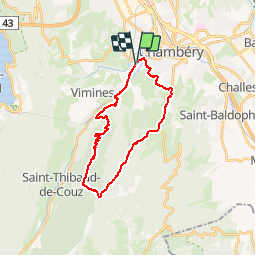
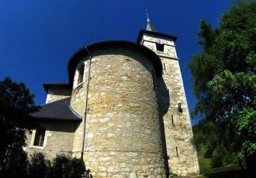
Trail Mountain bike of 25 km to be discovered at Auvergne-Rhône-Alpes, Savoy, Cognin. This trail is proposed by baudrine.

Description

12 kms d'ascension jusqu'au col du Planet, puis une superbe descente technique jusque dans les hauteurs de Montagnole.
Ensuite c'est un parcours ludique entre single et route.

Elevation profile

Positioning

Country:
France
Region :
Auvergne-Rhône-Alpes
Department/Province :
Savoy
Municipality :
Cognin
Location:
Unknown
Start:(UTM)
726020 ; 5049186 (31T) N.

Comments

Please log in to post a review or rate the element


ce parcours m'intéresse


Trails nearby

Trail Mountain bike Bassens - Pragondra - Photo
Mountain bike
Gorki

Mountain bike

Very easy
(1)
Bassens, Auvergne-Rhône-Alpes, Savoy, France
24 km | 34 km-effort
2h 49min
No
Trail Walking Saint-Alban-Leysse - 73- Le chemin des poussettes - Photo
Walking
cavpsy74

Walking

Easy
(1)
Saint-Alban-Leysse, Auvergne-Rhône-Alpes, Savoy, France
4.9 km | 10.6 km-effort
2h 2min
Yes
Trail Mountain bike Saint-Alban-Leysse - 2012-03-24 - Malpassant+ St sat - Photo
Mountain bike
maxx73

Mountain bike

Medium
(1)
Saint-Alban-Leysse, Auvergne-Rhône-Alpes, Savoy, France
27 km | 44 km-effort
3h 2min
Yes
Trail Walking Saint-Sulpice - Col du Crucifix par St Sulpice - Photo
Walking
brigittesontag

Walking

Medium
Saint-Sulpice, Auvergne-Rhône-Alpes, Savoy, France
5.5 km | 10.5 km-effort
2h 40min
Yes
Trail Walking Chambéry - Cascades de Jacob  - Photo
Walking
Michel_Martin

Walking

Easy
Chambéry, Auvergne-Rhône-Alpes, Savoy, France
10 km | 14 km-effort
2h 0min
Yes
Trail Mountain bike Barberaz - le Sire - Photo
Mountain bike
Gorki

Mountain bike

Easy
Barberaz, Auvergne-Rhône-Alpes, Savoy, France
40 km | 59 km-effort
7h 8min
Yes
Trail Running Cognin - Le Mont Grêle depuis Cognin - Photo
Running
tracegps

Running

Very difficult
Cognin, Auvergne-Rhône-Alpes, Savoy, France
34 km | 53 km-effort
4h 0min
Yes
Trail Mountain bike Cognin - Le Mont Grêle depuis Cognin - Photo
Mountain bike
tracegps

Mountain bike

Difficult
Cognin, Auvergne-Rhône-Alpes, Savoy, France
34 km | 53 km-effort
4h 40min
Yes
Trail Mountain bike La Motte-Servolex - Col du Crucifix via Bourdeau - Photo
Mountain bike
jimmyfend

Mountain bike

Difficult
(1)
La Motte-Servolex, Auvergne-Rhône-Alpes, Savoy, France
43 km | 61 km-effort
4h 0min
Yes


Close
My subscriptions