Trail Nordic walking Aigueperse - Château de la Roche  - Photo
 Gegetop
Gegetop

User

© OpenStreetMap contributors
Length
Length
10.1 km
Max alt
Max alt
492 m
Uphill gradient
Uphill gradient
226 m
Km-Effort
Km-Effort  
13.1 km
Min alt
Min alt
350 m
Downhill gradient
Downhill gradient
226 m
Boucle
Boucle
Yes
Creation date :
2019-01-15 16:48:44.848
Updated on :
2019-01-15 16:48:44.848

(0 Reviews)

Nordic walking
Nordic walking
2h26
Difficulty : Easy

Scan this QR Code to open this trail in the SityTrail application

FREE GPS app for hiking

Logo SityTrail SityTrail

IGN / Geographical institutes

Download SityTrail from the App Store Download SityTrail from Google Play

Logo SityTrail SityTrail World

The world is yours!

Download SityTrail from the App Store Download SityTrail from Google Play Download SityTrail on Huawei AppGallery

About

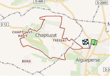
Trail Nordic walking of 10.1 km to be discovered at Auvergne-Rhône-Alpes, Puy-de-Dôme, Aigueperse. This trail is proposed by Gegetop.

Description

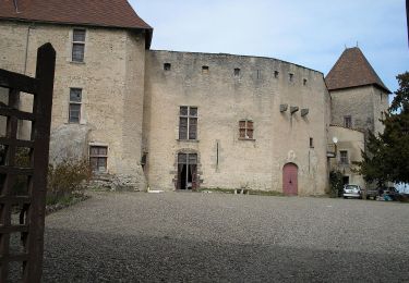
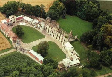
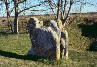
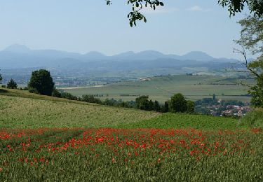
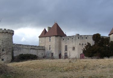
Balade sur les hauteurs de Chaptuzat haut, offrant une vue imprenable sur la limagne.

Elevation profile

Photos

Points of interest

Point of interest Aigueperse - Point 4 - Photo
Gegetop
AIGUEPERSE 

Positioning

Country:
France
Region :
Auvergne-Rhône-Alpes
Department/Province :
Puy-de-Dôme
Municipality :
Aigueperse
Location:
Unknown
Start:(UTM)
515706 ; 5096977 (31T) N.

Trails nearby

Trail Walking Artonne - D'Artonne à Chaptuzat - Photo
Walking
tracegps

Walking

Difficult
(1)
Artonne, Auvergne-Rhône-Alpes, Puy-de-Dôme, France
23 km | 30 km-effort
5h 49min
Yes
Trail Mountain bike Vensat - De Manoirs en Châteaux - Vensat - Photo
Mountain bike
tracegps

Mountain bike

Medium
(1)
Vensat, Auvergne-Rhône-Alpes, Puy-de-Dôme, France
13.4 km | 17.1 km-effort
1h 0min
Yes
Trail Walking Artonne - La croix des Rameaux - Photo
Walking
tracegps

Walking

Medium
(2)
Artonne, Auvergne-Rhône-Alpes, Puy-de-Dôme, France
11.2 km | 14.3 km-effort
2h 45min
Yes
Trail On foot Artonne - La Croix des Rameaux et le Puy St Jean - Photo
On foot
PRO

On foot

Easy
Artonne, Auvergne-Rhône-Alpes, Puy-de-Dôme, France
10.5 km | 13.6 km-effort
3h 5min
Yes
Trail On foot Aigueperse - Chateau de la Roche - Photo
On foot
PRO

On foot

Easy
Aigueperse, Auvergne-Rhône-Alpes, Puy-de-Dôme, France
9.6 km | 12.6 km-effort
2h 51min
No
Trail On foot Vensat - De manoirs en chateaux - Photo
On foot
PRO

On foot

Easy
Vensat, Auvergne-Rhône-Alpes, Puy-de-Dôme, France
9.5 km | 12.3 km-effort
2h 47min
Yes
Trail Walking Saint-Genès-du-Retz - St_Genes_Retz_Pierre_Sanglante - Photo
Walking
GUIDE
jagarnier

Walking

Easy
Saint-Genès-du-Retz, Auvergne-Rhône-Alpes, Puy-de-Dôme, France
9.6 km | 10.7 km-effort
2h 45min
Yes
Trail Walking Artonne - Artonne_Croix_Rameaux - Photo
Walking
GUIDE
jagarnier

Walking

Easy
Artonne, Auvergne-Rhône-Alpes, Puy-de-Dôme, France
10.4 km | 13.4 km-effort
3h 0min
Yes
Trail Walking Aigueperse - Le château de la Roche - Photo
Walking
tracegps

Walking

Medium
(3)
Aigueperse, Auvergne-Rhône-Alpes, Puy-de-Dôme, France
10 km | 13 km-effort
2h 34min
Yes


Close
My subscriptions