Trail Equestrian Quessoy - Quessoy la Ville Davy - Photo

Quessoy la Ville Davy

 tracegps
tracegps

User

© OpenStreetMap contributors
Length
Length
21 km
Max alt
Max alt
141 m
Uphill gradient
Uphill gradient
250 m
Km-Effort
Km-Effort  
24 km
Min alt
Min alt
57 m
Downhill gradient
Downhill gradient
250 m
Boucle
Boucle
Yes
Creation date :
2014-12-10 00:00:00.0
Updated on :
2014-12-10 00:00:00.0

(0 Reviews)

Equestrian
Equestrian
3h19
Difficulty : Medium

Scan this QR Code to open this trail in the SityTrail application

FREE GPS app for hiking

Logo SityTrail SityTrail

IGN / Geographical institutes

Download SityTrail from the App Store Download SityTrail from Google Play

Logo SityTrail SityTrail World

The world is yours!

Download SityTrail from the App Store Download SityTrail from Google Play Download SityTrail on Huawei AppGallery

About

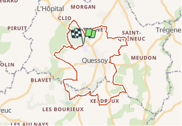
Trail Equestrian of 21 km to be discovered at Brittany, Côtes-d'Armor, Quessoy. This trail is proposed by tracegps.

Description

Circuit varié gué et rivière à traverser. Belles vues sur 2 châteaux.

Elevation profile

Positioning

Country:
France
Region :
Brittany
Department/Province :
Côtes-d'Armor
Municipality :
Quessoy
Location:
Unknown
Start:(UTM)
524576 ; 5363914 (30U) N.

Trails nearby

Trail Mountain bike Quessoy - quessoy - Photo
Mountain bike
lesaux

Mountain bike

Very easy
Quessoy, Brittany, Côtes-d'Armor, France
42 km | 50 km-effort
Unknown
No
Trail Bicycle tourism Yffiniac - Yffiniac st Brieuc vélo  - Photo
Bicycle tourism
foudebassan

Bicycle tourism

Easy
Yffiniac, Brittany, Côtes-d'Armor, France
7.5 km | 9.2 km-effort
1h 1min
No
Trail Walking Pommeret - Pommeret 1 - Photo
Walking
jymi

Walking

Easy
Pommeret, Brittany, Côtes-d'Armor, France
3.8 km | 4.2 km-effort
58min
Yes


Close
My subscriptions