Trail Running Toulouse - Les coteaux de Pech David - Photo

Les coteaux de Pech David

 tracegps
tracegps

User

© OpenStreetMap contributors
Length
Length
16.8 km
Max alt
Max alt
278 m
Uphill gradient
Uphill gradient
413 m
Km-Effort
Km-Effort  
22 km
Min alt
Min alt
162 m
Downhill gradient
Downhill gradient
415 m
Boucle
Boucle
Yes
Creation date :
2014-12-10 00:00:00.0
Updated on :
2014-12-10 00:00:00.0

(0 Reviews)

Running
Running
1h45
Difficulty : Difficult

Scan this QR Code to open this trail in the SityTrail application

FREE GPS app for hiking

Logo SityTrail SityTrail

IGN / Geographical institutes

Download SityTrail from the App Store Download SityTrail from Google Play

Logo SityTrail SityTrail World

The world is yours!

Download SityTrail from the App Store Download SityTrail from Google Play Download SityTrail on Huawei AppGallery

About

Trail Running of 16.8 km to be discovered at Occitania, Haute-Garonne, Toulouse. This trail is proposed by tracegps.

Description

Le parcours débute de la zone verte de Pech David, à côté du château d'eau. D'abord il longe le haut de la falaise surplombant la Garonne, offrant de belles vues sur le fleuve, l'agglomération toulousaine et par temps dégagé sur une large partie de la chaîne des Pyrénées. Après une succession de vallons aux pentes courtes mais raides, on rejoint les centres des communes de Pech Busque et de Vieille Toulouse. Le parcours est très varié, et offre quelques singles aux portes de Toulouse. A VTT, depuis Vielle Toulouse, il peut être prolongé à souhait en suivant les balisages jaunes du SICOVAL (un panneau du réseau de sentiers est situé à Vielle Toulouse, à quelques dizaines de mètres de l'itinéraire proposé). Le terrain est argileux, et donc boueux par endroit de décembre à mars surtout au fond des vallons. Le réseau pédestre du SICOVAL est consultable sur ce lien.

Elevation profile

Photos

Positioning

Country:
France
Region :
Occitania
Department/Province :
Haute-Garonne
Municipality :
Toulouse
Location:
Unknown
Start:(UTM)
374677 ; 4823961 (31T) N.

Trails nearby

Trail Walking Toulouse - Tour de Toulouse par la Garonne  - Photo
Walking
CooolGeorges

Walking

Medium
Toulouse, Occitania, Haute-Garonne, France
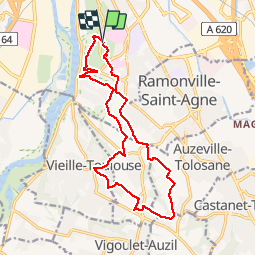
9.3 km | 11 km-effort
2h 35min
Yes
Trail Walking Castanet-Tolosan - casranzt fait - Photo
Walking
pidjam

Walking

Very easy
(1)
Castanet-Tolosan, Occitania, Haute-Garonne, France
10.5 km | 12.6 km-effort
2h 26min
Yes
Trail Walking Toulouse - Rive Droite Garonne Toulouse Gagnac - Photo
Walking
RR31

Walking

Easy
Toulouse, Occitania, Haute-Garonne, France
24 km | 27 km-effort
5h 55min
No
Trail Walking Toulouse - Rive Droite Garonne Toulouse Gagnac - Photo
Walking
RR31

Walking

Easy
Toulouse, Occitania, Haute-Garonne, France
24 km | 27 km-effort
5h 55min
No
Trail Walking Castanet-Tolosan - Boucle de Savignol  -  Castanet-Tolosan - Photo
Walking
tracegps

Walking

Medium
Castanet-Tolosan, Occitania, Haute-Garonne, France
10 km | 12.2 km-effort
2h 30min
Yes
Trail Walking Pechbusque - De Pechbusque à Auzeville Tolosane - Photo
Walking
tracegps

Walking

Medium
Pechbusque, Occitania, Haute-Garonne, France
11.2 km | 14.2 km-effort
3h 30min
Yes
Trail Walking Toulouse - TT22 Bellefontaine variante - Photo
Walking

Walking

Medium
Toulouse, Occitania, Haute-Garonne, France
11 km | 12.3 km-effort
2h 0min
No
Trail Walking Toulouse - SityTrail - TT22 - Toulouse - Saouzelong - simple - Photo
Walking

Walking

Easy
Toulouse, Occitania, Haute-Garonne, France
5.8 km | 6.3 km-effort
1h 30min
No
Trail Walking Toulouse - TT22 Bellefontaine - Photo
Walking

Walking

Medium
Toulouse, Occitania, Haute-Garonne, France
10.7 km | 12.1 km-effort
2h 0min
No


Close
My subscriptions