Trail Walking Liévin - 50 km Lievin en nocturne - Photo

50 km Lievin en nocturne

 tracegps
tracegps

User

© OpenStreetMap contributors
Length
Length
52 km
Max alt
Max alt
195 m
Uphill gradient
Uphill gradient
685 m
Km-Effort
Km-Effort  
61 km
Min alt
Min alt
37 m
Downhill gradient
Downhill gradient
678 m
Boucle
Boucle
Yes
Creation date :
2014-12-10 00:00:00.0
Updated on :
2014-12-10 00:00:00.0

(1 Reviews)

Walking
Walking
9h00
Difficulty : Very difficult

Scan this QR Code to open this trail in the SityTrail application

FREE GPS app for hiking

Logo SityTrail SityTrail

IGN / Geographical institutes

Download SityTrail from the App Store Download SityTrail from Google Play

Logo SityTrail SityTrail World

The world is yours!

Download SityTrail from the App Store Download SityTrail from Google Play Download SityTrail on Huawei AppGallery

About

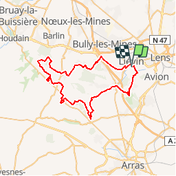
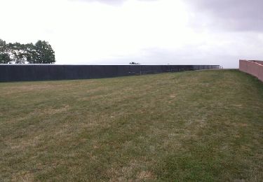
Trail Walking of 52 km to be discovered at Hauts-de-France, Pas-de-Calais, Liévin. This trail is proposed by tracegps.

Description

Randonnée nocturne autour de Lievin, organisée au printemps.

Elevation profile

Positioning

Country:
France
Region :
Hauts-de-France
Department/Province :
Pas-de-Calais
Municipality :
Liévin
Location:
Unknown
Start:(UTM)
484013 ; 5585065 (31U) N.

Comments

Please log in to post a review or rate the element


Respecte bien le tracé de la rando


Trails nearby

Trail Walking Lens - randonnée  - Photo
Walking
sandrine brisset

Walking

Difficult
Lens, Hauts-de-France, Pas-de-Calais, France
10.5 km | 13.4 km-effort
3h 41min
Yes
Trail Walking Angres - randonnée pinchonvalles - Photo
Walking
Chene62

Walking

Very difficult
Angres, Hauts-de-France, Pas-de-Calais, France
27 km | 0 m-effort
3h 24min
No
Trail Other activity Liévin - boucle Liévin - Photo
Other activity
crijack

Other activity

Very easy
Liévin, Hauts-de-France, Pas-de-Calais, France
11 km | 12.3 km-effort
2h 2min
Yes
Trail Other activity Liévin - boucle Liévin - Photo
Other activity
crijack

Other activity

Very easy
Liévin, Hauts-de-France, Pas-de-Calais, France
11 km | 12.3 km-effort
2h 2min
Yes
Trail Running Aix-Noulette - aix noulette sity guide 25,3 km D530+ - Photo
Running
jamboxland

Running

Medium
Aix-Noulette, Hauts-de-France, Pas-de-Calais, France
23 km | 30 km-effort
2h 45min
Yes
Trail Walking Souchez - Souchez-Noulette-Lorette-Ablain - Photo
Walking
tracegps

Walking

Easy
Souchez, Hauts-de-France, Pas-de-Calais, France
6.7 km | 8.4 km-effort
1h 45min
Yes
Trail Walking Ablain-Saint-Nazaire - lorette août 23 - Photo
Walking
Benoît66

Walking

Difficult
Ablain-Saint-Nazaire, Hauts-de-France, Pas-de-Calais, France
11.8 km | 15.6 km-effort
2h 29min
No
Trail Walking Ablain-Saint-Nazaire - autour d'Alain Saint nazaire - Photo
Walking
temmichel

Walking

Medium
Ablain-Saint-Nazaire, Hauts-de-France, Pas-de-Calais, France
8.9 km | 11.1 km-effort
2h 4min
Yes
Trail Walking Souchez - Lorette et Carency CAF - Photo
Walking
reneperrin

Walking

Easy
Souchez, Hauts-de-France, Pas-de-Calais, France
21 km | 25 km-effort
5h 24min
Yes


Close
My subscriptions