Trail Snowshoes Prayols - Le Picou du Prat d'Albis - Photo

Le Picou du Prat d'Albis

 tracegps
tracegps

User

© OpenStreetMap contributors
Length
Length
14.9 km
Max alt
Max alt
1621 m
Uphill gradient
Uphill gradient
601 m
Km-Effort
Km-Effort  
23 km
Min alt
Min alt
1105 m
Downhill gradient
Downhill gradient
614 m
Boucle
Boucle
No
Creation date :
2014-12-10 00:00:00.0
Updated on :
2014-12-10 00:00:00.0

(0 Reviews)

Snowshoes
Snowshoes
5h00
Difficulty : Difficult

Scan this QR Code to open this trail in the SityTrail application

FREE GPS app for hiking

Logo SityTrail SityTrail

IGN / Geographical institutes

Download SityTrail from the App Store Download SityTrail from Google Play

Logo SityTrail SityTrail World

The world is yours!

Download SityTrail from the App Store Download SityTrail from Google Play Download SityTrail on Huawei AppGallery

About

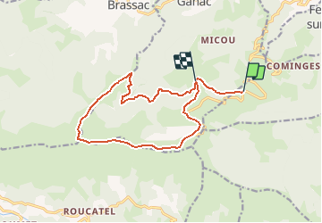
Trail Snowshoes of 14.9 km to be discovered at Occitania, Ariège, Prayols. This trail is proposed by tracegps.

Description

La balade part du Prat d'Albis au sud-ouest de Foix par la D421. En début de saison, la route peut être enneigée. Il sera nécessaire de partir de plus bas. La première partie s'effectue en versant Nord sur une route forestière à l'enneigement tardif. La montée vers le Picou se fait par le Nord. Par beau temps on appréciera le panorama sur les Pyrénées ariégeoises et la vue à 360° permettant d'apercevoir le Vallier, le Fourcat, le Saint Barthelémy, Roquefixade, Montségur... Le retour emprunte en partie le GR Pays du tour de la Barguillère. On peut agrémenter le retour en passant par le Bout de Touron.

Elevation profile

Positioning

Country:
France
Region :
Occitania
Department/Province :
Ariège
Municipality :
Prayols
Location:
Unknown
Start:(UTM)
384198 ; 4753048 (31T) N.

Trails nearby

Trail Mountain bike Ganac - Prat Albis - Verniolle - Photo
Mountain bike
daliot

Mountain bike

Difficult
(1)
Ganac, Occitania, Ariège, France
30 km | 36 km-effort
2h 30min
No
Trail Running Mercus-Garrabet - mercus1 - Photo
Running
gilbertcaujolle

Running

Very easy
(1)
Mercus-Garrabet, Occitania, Ariège, France
20 km | 37 km-effort
5h 6min
Yes
Trail Walking Prayols - Cuminge  - Photo
Walking
David Girabet

Walking

Easy
(1)
Prayols, Occitania, Ariège, France
3.5 km | 6.1 km-effort
1h 0min
Yes
Trail Walking Ganac - Prat d'Albis - Photo
Walking
caccini

Walking

Very easy
Ganac, Occitania, Ariège, France
8.6 km | 12.6 km-effort
3h 2min
No
Trail On foot Brassac - Le Picou depuis Brassac - Photo
On foot
PRO

On foot

Easy
Brassac, Occitania, Ariège, France
5 km | 14.7 km-effort
3h 20min
No
Trail Walking Montoulieu - MONTOULIEU - GINABAT - Photo
Walking
RonanDAGORN

Walking

Medium
Montoulieu, Occitania, Ariège, France
7.1 km | 10.3 km-effort
1h 53min
Yes
Trail On foot Montoulieu - La cabane des gardes - Photo
On foot
c.chehere

On foot

Medium
Montoulieu, Occitania, Ariège, France
15.5 km | 25 km-effort
Unknown
Yes
Trail Walking Mercus-Garrabet - Mercus-Garabet - Photo
Walking
c.chehere

Walking

Easy
Mercus-Garrabet, Occitania, Ariège, France
15.5 km | 25 km-effort
7h 45min
No
Trail Walking Foix - 01 - FOIX à ROQUEFIXADE - Chemin des Bons-Hommes GR107 GR367 - Photo
Walking
jopost

Walking

Difficult
Foix, Occitania, Ariège, France
18.6 km | 30 km-effort
6h 36min
No


Close
My subscriptions