Trail Walking Saint-Christophe-en-Oisans - Tour de la Bérarde - Étape n°2 : Refuge Temple des Écrins - Refuge de la Pilatte - Photo

Tour de la Bérarde - Étape n°2 : Refuge Temple des Écrins - Refuge de la Pilatte

 tracegps
tracegps

User

© OpenStreetMap contributors
Length
Length
6.6 km
Max alt
Max alt
2583 m
Uphill gradient
Uphill gradient
581 m
Km-Effort
Km-Effort  
13.8 km
Min alt
Min alt
1990 m
Downhill gradient
Downhill gradient
405 m
Boucle
Boucle
No
Creation date :
2014-12-10 00:00:00.0
Updated on :
2014-12-10 00:00:00.0

(0 Reviews)

Walking
Walking
3h30
Difficulty : Medium

Scan this QR Code to open this trail in the SityTrail application

FREE GPS app for hiking

Logo SityTrail SityTrail

IGN / Geographical institutes

Download SityTrail from the App Store Download SityTrail from Google Play

Logo SityTrail SityTrail World

The world is yours!

Download SityTrail from the App Store Download SityTrail from Google Play Download SityTrail on Huawei AppGallery

About

Trail Walking of 6.6 km to be discovered at Auvergne-Rhône-Alpes, Isère, Saint-Christophe-en-Oisans. This trail is proposed by tracegps.

Description

Redescendre du Refuge du Temple des Écrins, longer la rivière jusqu'à une passerelle qu’il faut traverser, boire un coup et monter vers Pilatte. Refuge de la Pilatte, tél.: 04/92241417

Elevation profile

Photos

Positioning

Country:
France
Region :
Auvergne-Rhône-Alpes
Department/Province :
Isère
Municipality :
Saint-Christophe-en-Oisans
Location:
Unknown
Start:(UTM)
289402 ; 4975761 (32T) N.

Trails nearby

Trail Walking Saint-Christophe-en-Oisans - Cornes de Pié Bérarde  - Photo
Walking
chuck

Walking

Very difficult
Saint-Christophe-en-Oisans, Auvergne-Rhône-Alpes, Isère, France
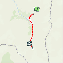
9.8 km | 27 km-effort
6h 7min
Yes
Trail Walking Saint-Christophe-en-Oisans - Rando depart du refuge du Carrelet et arrivée à La Berarde - Photo
Walking
HF89

Walking

Easy
Saint-Christophe-en-Oisans, Auvergne-Rhône-Alpes, Isère, France
4.4 km | 5.3 km-effort
1h 10min
No
Trail Walking Saint-Christophe-en-Oisans - Malraux Refuge du Chateleret - Photo
Walking
rapako

Walking

Easy
Saint-Christophe-en-Oisans, Auvergne-Rhône-Alpes, Isère, France
12.1 km | 19.4 km-effort
5h 26min
Yes
Trail Walking Saint-Christophe-en-Oisans - Oisans - La Bérarde Chatelleret - 11km 400m 3h25 - 2018 06 22 - public - Photo
Walking
Orcal37

Walking

Medium
Saint-Christophe-en-Oisans, Auvergne-Rhône-Alpes, Isère, France
10.8 km | 16 km-effort
5h 30min
Yes
Trail Walking Saint-Christophe-en-Oisans - REFUGE DE CHATELLERET depuis LA BERARDE-07-09-2016 - Photo
Walking
RD78-38

Walking

Easy
Saint-Christophe-en-Oisans, Auvergne-Rhône-Alpes, Isère, France
14.9 km | 25 km-effort
6h 30min
Yes
Trail Walking Saint-Christophe-en-Oisans - Oisans - Vénéon - La Bérarde - Le Chatelleret - Photo
Walking
Orcal37

Walking

Medium
Saint-Christophe-en-Oisans, Auvergne-Rhône-Alpes, Isère, France
7.9 km | 10.8 km-effort
2h 50min
Yes
Trail Walking Saint-Christophe-en-Oisans - Oisans La Bérarde Vallée du Vénéon  - Photo
Walking
Orcal37

Walking

Medium
Saint-Christophe-en-Oisans, Auvergne-Rhône-Alpes, Isère, France
13.4 km | 18.5 km-effort
4h 1min
Yes
Trail Walking Saint-Christophe-en-Oisans - Crique Glaciaire de Bonne Piere - Photo
Walking
franck38

Walking

Difficult
Saint-Christophe-en-Oisans, Auvergne-Rhône-Alpes, Isère, France
11.4 km | 27 km-effort
5h 27min
Yes
Trail Walking Saint-Christophe-en-Oisans - Tour de la Bérarde - Étape n°3 : Refuge de la Pilatte - La Bérarde - Photo
Walking
tracegps

Walking

Medium
(1)
Saint-Christophe-en-Oisans, Auvergne-Rhône-Alpes, Isère, France
9.9 km | 13 km-effort
4h 0min
No


Close
My subscriptions