Trail Mountain bike Saint-Gatien-des-Bois - Rando VTT Saint Gatien des Bois - Photo

Rando VTT Saint Gatien des Bois

 tracegps
tracegps

User

© OpenStreetMap contributors
Length
Length
26 km
Max alt
Max alt
151 m
Uphill gradient
Uphill gradient
318 m
Km-Effort
Km-Effort  
30 km
Min alt
Min alt
9 m
Downhill gradient
Downhill gradient
318 m
Boucle
Boucle
Yes
Creation date :
2014-12-10 00:00:00.0
Updated on :
2014-12-10 00:00:00.0

(0 Reviews)

Mountain bike
Mountain bike
2h15
Difficulty : Medium

Scan this QR Code to open this trail in the SityTrail application

FREE GPS app for hiking

Logo SityTrail SityTrail

IGN / Geographical institutes

Download SityTrail from the App Store Download SityTrail from Google Play

Logo SityTrail SityTrail World

The world is yours!

Download SityTrail from the App Store Download SityTrail from Google Play Download SityTrail on Huawei AppGallery

About

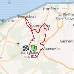
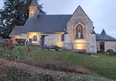
Trail Mountain bike of 26 km to be discovered at Normandy, Calvados, Saint-Gatien-des-Bois. This trail is proposed by tracegps.

Description

Randonnée VTT sous forme de boucle au départ de Saint Gatien des bois. Passage par Barneville La Bertrand, Pennedepie, Equemauville et Gonneville sur Honfleur. 1ère partie roulante 5 km de route, la suite se corse avec la grande montée dans la forêt située derrière l'Hôpital d'Equemauville, ensuite grande descente technique et passage et roulage dans un petit ruisseau. Ensuite remontée sur les hauteurs de Gonneville sur Honfleur, puis retour sur Saint Gatien des Bois par divers chemins et par la route.

Elevation profile

Positioning

Country:
France
Region :
Normandy
Department/Province :
Calvados
Municipality :
Saint-Gatien-des-Bois
Location:
Unknown
Start:(UTM)
295492 ; 5470006 (31U) N.

Trails nearby

Trail Walking Équemauville - 076-63 -Honfleur 22km--596-772 - Photo
Walking
rvs147

Walking

Easy
(1)
Équemauville, Normandy, Calvados, France
21 km | 27 km-effort
3h 34min
Yes
Trail On foot Le Theil-en-Auge - La Vallée de l'Orange - Photo
On foot
GUIDE+

On foot

Easy
Le Theil-en-Auge, Normandy, Calvados, France
3.5 km | 3.8 km-effort
52min
No
Trail Walking Barneville-la-Bertran - Honfleur  - Photo
Walking
bernardb2

Walking

Medium
Barneville-la-Bertran, Normandy, Calvados, France
8.1 km | 9.8 km-effort
2h 10min
Yes
Trail Mountain bike Fourneville - Rando Fourneville Calvados Normandie - Photo
Mountain bike
tracegps

Mountain bike

Difficult
Fourneville, Normandy, Calvados, France
26 km | 32 km-effort
2h 40min
Yes
Trail Walking Fourneville - Rando Fourneville Calvados Normandie - Photo
Walking
tracegps

Walking

Very difficult
Fourneville, Normandy, Calvados, France
26 km | 32 km-effort
5h 0min
Yes
Trail Walking Vieux-Bourg - Vieux Bourg - Photo
Walking
Eve - Line

Walking

Medium
(1)
Vieux-Bourg, Normandy, Calvados, France
12.3 km | 15.8 km-effort
3h 10min
Yes
Trail Hybrid bike Équemauville - Normandie région Honfleur - Photo
Hybrid bike
sperchant

Hybrid bike

Easy
Équemauville, Normandy, Calvados, France
30 km | 34 km-effort
5h 48min
Yes
Trail Walking Équemauville - boucle Equemauville - côte de Grace  - Photo
Walking
prv

Walking

Very easy
Équemauville, Normandy, Calvados, France
10.1 km | 11 km-effort
2h 4min
Yes
Trail Via ferrata Saint-Gatien-des-Bois - 2013-05-09 15h06m55 - Photo
Via ferrata
wusu

Via ferrata

Easy
(2)
Saint-Gatien-des-Bois, Normandy, Calvados, France
1.7 km | 2 km-effort
Unknown
Yes


Close
My subscriptions