Trail Mountain bike Neufchâtel-en-Saosnois - Randonée VTT Transperseigne 2010 -  25 km - Neufchâtel en Saosnois  - Photo

Randonée VTT Transperseigne 2010 - 25 km - Neufchâtel en Saosnois

 tracegps
tracegps

User

© OpenStreetMap contributors
Length
Length
23 km
Max alt
Max alt
358 m
Uphill gradient
Uphill gradient
610 m
Km-Effort
Km-Effort  
31 km
Min alt
Min alt
162 m
Downhill gradient
Downhill gradient
611 m
Boucle
Boucle
Yes
Creation date :
2014-12-10 00:00:00.0
Updated on :
2014-12-10 00:00:00.0

(0 Reviews)

Mountain bike
Mountain bike
2h30
Difficulty : Difficult

Scan this QR Code to open this trail in the SityTrail application

FREE GPS app for hiking

Logo SityTrail SityTrail

IGN / Geographical institutes

Download SityTrail from the App Store Download SityTrail from Google Play

Logo SityTrail SityTrail World

The world is yours!

Download SityTrail from the App Store Download SityTrail from Google Play Download SityTrail on Huawei AppGallery

About

Trail Mountain bike of 23 km to be discovered at Pays de la Loire, Sarthe, Neufchâtel-en-Saosnois. This trail is proposed by tracegps.

Description

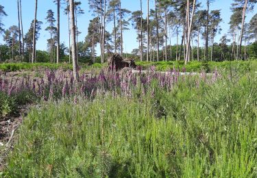
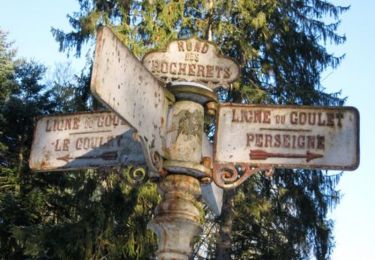
Randonnée dans la forêt domaniale de Perseigne à coté de Neufchâtel en Saosnois entre Alençon (61)et Samer (72. Parcours magnifique à fort dénivelé dans une forêt superbe, à faire absolument !! Et beaucoup d'autres randonnées possibles dans cette forêt, voir les balisages.

Elevation profile

Positioning

Country:
France
Region :
Pays de la Loire
Department/Province :
Sarthe
Municipality :
Neufchâtel-en-Saosnois
Location:
Unknown
Start:(UTM)
297240 ; 5363415 (31U) N.

Trails nearby

Trail Walking Neufchâtel-en-Saosnois - Perseigne - Abbaye 8,3 km - Photo
Walking
ODDAD78

Walking

Easy
(1)
Neufchâtel-en-Saosnois, Pays de la Loire, Sarthe, France
8.4 km | 11.1 km-effort
2h 22min
Yes
Trail Nordic walking Louzes - belvédère de Perseigne - Photo
Nordic walking
yvesportier

Nordic walking

Medium
Louzes, Pays de la Loire, Sarthe, France
7.3 km | 9.5 km-effort
1h 30min
Yes
Trail Mountain bike Neufchâtel-en-Saosnois - La Laurent Brochard 2011 - Neufchatel en Saônois - Photo
Mountain bike
tracegps

Mountain bike

Medium
Neufchâtel-en-Saosnois, Pays de la Loire, Sarthe, France
35 km | 43 km-effort
2h 19min
Yes
Trail Mountain bike Villaines-la-Carelle -  Forêt de Perseigne et Haute Sarthe - Circuit n°6  - Photo
Mountain bike
tracegps

Mountain bike

Difficult
Villaines-la-Carelle, Pays de la Loire, Sarthe, France
26 km | 34 km-effort
2h 30min
Yes
Trail Mountain bike Ancinnes - La Laurent Brochard 2008 - Saint Rigomer des Bois - Photo
Mountain bike
tracegps

Mountain bike

Very difficult
Ancinnes, Pays de la Loire, Sarthe, France
49 km | 61 km-effort
4h 0min
No
Trail Walking Neufchâtel-en-Saosnois - Perseigne Abbaye 7,7 Km - Photo
Walking
ODDAD78

Walking

Easy
Neufchâtel-en-Saosnois, Pays de la Loire, Sarthe, France
7.7 km | 10.1 km-effort
2h 11min
Yes
Trail Walking Neufchâtel-en-Saosnois - Perseigne Abbaye 6,7 km - Photo
Walking
ODDAD78

Walking

Easy
Neufchâtel-en-Saosnois, Pays de la Loire, Sarthe, France
6.7 km | 8.6 km-effort
1h 52min
Yes
Trail Walking Villaines-la-Carelle - Perseigne 005 10,2km - Photo
Walking
ODDAD78

Walking

Medium
Villaines-la-Carelle, Pays de la Loire, Sarthe, France
10.2 km | 13.5 km-effort
2h 53min
Yes
Trail Walking Neufchâtel-en-Saosnois - Perseigne Carrefour des Trois Points - Belvédère 8,7km - Photo
Walking
ODDAD78

Walking

Easy
Neufchâtel-en-Saosnois, Pays de la Loire, Sarthe, France
8.7 km | 12.2 km-effort
2h 33min
Yes


Close
My subscriptions