


Montagnette_2018

gmarchas
User
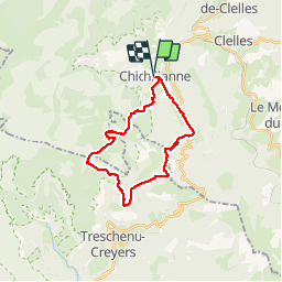

Length
23 km

Max alt
1959 m

Uphill gradient
1495 m
Km-Effort
43 km

Min alt
985 m

Downhill gradient
1496 m
Boucle
Yes
Creation date :
2019-01-15 17:16:27.551
Updated on :
2019-01-15 17:16:27.551
6h31
Difficulty : Difficult

FREE GPS app for hiking
 SityTrail
IGN / Geographical institutes
SityTrail Plus
The world is yours!
About
Trail Walking of 23 km to be discovered at Auvergne-Rhône-Alpes, Isère, Chichilianne. This trail is proposed by gmarchas.
Positioning
Country:
France
Region :
Auvergne-Rhône-Alpes
Department/Province :
Isère
Municipality :
Chichilianne
Location:
Unknown
Start:(Dec)
Start:(UTM)
703475 ; 4965205 (31T) N.
Comments