Trail Running Ainhoa - Ainhoa - L'Erebi - Photo
 tracegps
tracegps

User

© OpenStreetMap contributors
Length
Length
9.3 km
Max alt
Max alt
575 m
Uphill gradient
Uphill gradient
497 m
Km-Effort
Km-Effort  
15.9 km
Min alt
Min alt
104 m
Downhill gradient
Downhill gradient
502 m
Boucle
Boucle
Yes
Creation date :
2014-12-10 00:00:00.0
Updated on :
2014-12-10 00:00:00.0

(1 Reviews)

Running
Running
1h00
Difficulty : Difficult

Scan this QR Code to open this trail in the SityTrail application

FREE GPS app for hiking

Logo SityTrail SityTrail

IGN / Geographical institutes

Download SityTrail from the App Store Download SityTrail from Google Play

Logo SityTrail SityTrail World

The world is yours!

Download SityTrail from the App Store Download SityTrail from Google Play Download SityTrail on Huawei AppGallery

About

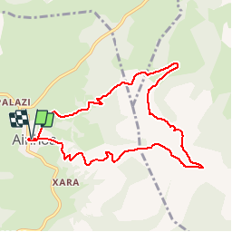
Trail Running of 9.3 km to be discovered at New Aquitaine, Pyrénées-Atlantiques, Ainhoa. This trail is proposed by tracegps.

Description

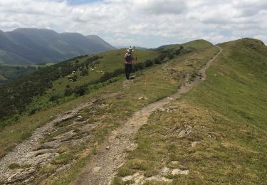
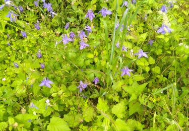
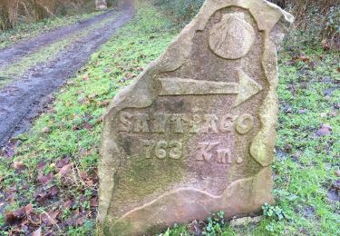
L'Erebi, à 583m d'altitude, domine le magnifique village d'Ainhoa. Cette randonnée offre de superbes panoramas sur le Pays Basque, la Rhune, l'Océan de Cap Breton à Saint Jean de Luz. D'Ainhoa, suivre le GR10. A mi hauteur on atteint une chapelle, bordée par un calvaire et de nombreuses croix discoïdales dans un paysage à couper le souffle. e la chapelle on monte hors balisage vers le sommet de l'Erebi. En étant attentif, on observe de nombreux vautours perchés sur des rochers à quelques dizaines de mètres du chemin. A moins qu'ils ne vous survolent évaluant votre forme physique et les promesses d'un futur festin ! Les pottoks sont également nombreux, loin des foules de la Rhune.

Elevation profile

Photos

Positioning

Country:
France
Region :
New Aquitaine
Department/Province :
Pyrénées-Atlantiques
Municipality :
Ainhoa
Location:
Unknown
Start:(UTM)
621815 ; 4795982 (30T) N.

Comments

Please log in to post a review or rate the element


Belle randonnée raide


Trails nearby

Trail Walking Espelette - Erreka mondarain col des veaux - Photo
Walking
GUIDE
antignacs

Walking

Difficult
(1)
Espelette, New Aquitaine, Pyrénées-Atlantiques, France
18.3 km | 29 km-effort
6h 34min
Yes
Trail Walking Urdazubi/Urdax - urdax  - Photo
Walking
RayFab

Walking

Medium
(1)
Urdazubi/Urdax, Navarre, Unknown, Spain
15.7 km | 25 km-effort
4h 56min
No
Trail Walking Espelette - De la Nive à la Nivelle - Circuit des familles - Espelette - Photo
Walking
tracegps

Walking

Easy
(1)
Espelette, New Aquitaine, Pyrénées-Atlantiques, France
7.1 km | 9.2 km-effort
1h 30min
Yes
Trail Walking Espelette - ESPELETTE Le circuit des familles
Walking
GUIDE
marmotte65

Walking

Medium
Espelette, New Aquitaine, Pyrénées-Atlantiques, France
7.5 km | 9.6 km-effort
1h 55min
Yes
Trail Walking Saint-Pée-sur-Nivelle - Cherchebruit pinodieta ainhoa  - Photo
Walking
GUIDE
antignacs

Walking

Easy
Saint-Pée-sur-Nivelle, New Aquitaine, Pyrénées-Atlantiques, France
19.3 km | 27 km-effort
5h 59min
Yes
Trail On foot Urdazubi/Urdax - SL-NA 15 Otsondottiki - Photo
On foot
PRO

On foot

Easy
Urdazubi/Urdax, Navarre, Unknown, Spain
8.4 km | 13.4 km-effort
3h 2min
Yes
Trail On foot Urdazubi/Urdax - SL-NA 17 Axularren txokoa - Photo
On foot
PRO

On foot

Easy
Urdazubi/Urdax, Navarre, Unknown, Spain
4.9 km | 8.1 km-effort
1h 50min
Yes
Trail Walking Urdazubi/Urdax - Urdax Lizartzu circuit des bunkers - Photo
Walking
DECHAMPD

Walking

Medium
(1)
Urdazubi/Urdax, Navarre, Unknown, Spain
15.5 km | 26 km-effort
5h 22min
Yes
Trail On foot Urdazubi/Urdax - urdax - Photo
On foot
jaja64

On foot

Easy
Urdazubi/Urdax, Navarre, Unknown, Spain
9.7 km | 16.2 km-effort
3h 41min
Yes


Close
My subscriptions