Trail Running Seine-Port - Fore?t de Rougeau et bords de Seine - Photo

Fore?t de Rougeau et bords de Seine

 tracegps
tracegps

User

© OpenStreetMap contributors
Length
Length
28 km
Max alt
Max alt
99 m
Uphill gradient
Uphill gradient
234 m
Km-Effort
Km-Effort  
32 km
Min alt
Min alt
36 m
Downhill gradient
Downhill gradient
232 m
Boucle
Boucle
No
Creation date :
2014-12-10 00:00:00.0
Updated on :
2014-12-10 00:00:00.0

(2 Reviews)

Running
Running
3h30
Difficulty : Very difficult

Scan this QR Code to open this trail in the SityTrail application

FREE GPS app for hiking

Logo SityTrail SityTrail

IGN / Geographical institutes

Download SityTrail from the App Store Download SityTrail from Google Play

Logo SityTrail SityTrail World

The world is yours!

Download SityTrail from the App Store Download SityTrail from Google Play Download SityTrail on Huawei AppGallery

About

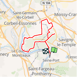
Trail Running of 28 km to be discovered at Ile-de-France, Seine-et-Marne, Seine-Port. This trail is proposed by tracegps.

Description

La forêt de Rougeau est située dans le prolongement de la forêt de Sénart, sur deux départements: l'Essonne et la Seine-et-Marne. Cette forêt a la particularité d'avoir un coteau calcaire surplombant la Seine qui est très intéressant et très riche en flore. Rougeau offre un réseau dense de routes forestières et de sentiers. Arpentée par les promeneurs, cueilleurs et cavaliers. Belle vue sur les bords de Seine.

Elevation profile

Photos

Positioning

Country:
France
Region :
Ile-de-France
Department/Province :
Seine-et-Marne
Municipality :
Seine-Port
Location:
Unknown
Start:(UTM)
466710 ; 5378962 (31U) N.

Comments

Please log in to post a review or rate the element


Merci


Trails nearby

Trail Walking Savigny-le-Temple - Entre Savigny-le-Temple et Seine-Port - Photo
Walking
DUGAEL

Walking

Very easy
(1)
Savigny-le-Temple, Ile-de-France, Seine-et-Marne, France
11 km | 12.8 km-effort
2h 59min
No
Trail Walking Cesson - JC 20   19.50 km  -  Cesson la Forêt, forêt de Bréviande - Photo
Walking

Walking

Difficult
(2)
Cesson, Ile-de-France, Seine-et-Marne, France
19.1 km | 21 km-effort
4h 48min
Yes
Trail Walking Cesson - 2020-09-30_18h09m29_JaINFIZemJ8 - Photo
Walking

Walking

Medium
(1)
Cesson, Ile-de-France, Seine-et-Marne, France
11.5 km | 13 km-effort
2h 56min
Yes
Trail Walking Vert-Saint-Denis - 20220330 - Forêt de Bréviande 15km - Photo
Walking
GUIDE
jeanmarcMasson

Walking

Difficult
(1)
Vert-Saint-Denis, Ile-de-France, Seine-et-Marne, France
14.6 km | 16.3 km-effort
3h 42min
Yes
Trail Walking Nandy - 2017-10-05-Cesson - Photo
Walking

Walking

Difficult
(1)
Nandy, Ile-de-France, Seine-et-Marne, France
21 km | 24 km-effort
5h 32min
Yes
Trail On foot Saint-Pierre-du-Perray - 2020-10-20_05h12m58_R2iIxMbsAX0 - Photo
On foot

On foot

Very easy
(1)
Saint-Pierre-du-Perray, Ile-de-France, Essonne, France
7.3 km | 7.9 km-effort
1h 47min
Yes
Trail Walking Boissise-la-Bertrand - vives eaux 2019 - Photo
Walking
grene

Walking

Very easy
(1)
Boissise-la-Bertrand, Ile-de-France, Seine-et-Marne, France
11.3 km | 12.9 km-effort
2h 45min
Yes
Trail Walking Saint-Fargeau-Ponthierry - Ponthierry rando des lavoirs - Photo
Walking
CDieu

Walking

Very easy
Saint-Fargeau-Ponthierry, Ile-de-France, Seine-et-Marne, France
14.3 km | 16 km-effort
5h 43min
Yes
Trail Walking Boissise-la-Bertrand - Boucle Boissise la BERTRAND 30 km - Photo
Walking
chessyca

Walking

Very difficult
Boissise-la-Bertrand, Ile-de-France, Seine-et-Marne, France
32 km | 36 km-effort
6h 36min
Yes


Close
My subscriptions