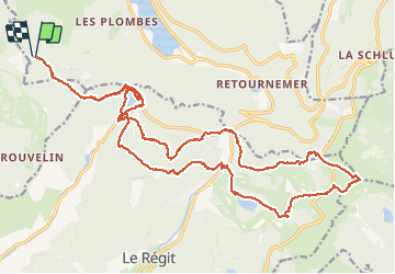
22 km | 35 km-effort
LE HOHNECK
0010Jacem.1957
User
Length
29 km
Max alt
1355 m
Uphill gradient
1164 m
Km-Effort
44 km
Min alt
906 m
Downhill gradient
1165 m
Boucle
Yes
Creation date :
2019-01-15 17:49:34.507
Updated on :
2019-01-15 17:49:34.507
7h59
Difficulty : Difficult
FREE GPS app for hiking
About
Trail Walking of 29 km to be discovered at Grand Est, Vosges, Xonrupt-Longemer. This trail is proposed by 0010Jacem.1957.
Description
Quelques passages techniques surtout par temps humide
Positioning
Country:
France
Region :
Grand Est
Department/Province :
Vosges
Municipality :
Xonrupt-Longemer
Location:
Unknown
Start:(Dec)
Start:(UTM)
344606 ; 5325434 (32U) N.
Comments
Trails nearby
2023-04-15 Marche Abri Collet de Etang vers Abri Lac de Blanchemer
Walking
Medium
(1)
La Bresse,
Grand Est,
Vosges,
France
7h 51min
No
Lac de Lispach et sentier Dielaine
Walking
Medium
(1)
La Bresse,
Grand Est,
Vosges,
France
9.7 km | 14.9 km-effort
2h 30min
Yes
ramonchamp. observatoire de merelle, saut de la bourrique
Nordic walking
Difficult
(1)
Gérardmer,
Grand Est,
Vosges,
France
11.1 km | 15.8 km-effort
3h 30min
Yes
Les 5 lacs autour du Hohneck
Walking
Very difficult
(1)
La Bresse,
Grand Est,
Vosges,
France
21 km | 36 km-effort
7h 21min
Yes
lac de Lispach
Walking
Easy
(1)
La Bresse,
Grand Est,
Vosges,
France
10.4 km | 14.1 km-effort
4h 6min
Yes
lac de Lispach
Walking
Easy
(3)
La Bresse,
Grand Est,
Vosges,
France
10.4 km | 14.1 km-effort
4h 6min
Yes
randonnée découverte à la Bresse.
Mountain bike
Easy
(1)
La Bresse,
Grand Est,
Vosges,
France
30 km | 41 km-effort
2h 58min
Yes
La vallée de Belbriette - Ban-sur-Meurthe-Clefcy
Walking
Medium
(2)
Ban-sur-Meurthe-Clefcy,
Grand Est,
Vosges,
France
9.8 km | 12.6 km-effort
2h 30min
Yes
La Tête de Mérelle
Walking
Medium
(4)
Gérardmer,
Grand Est,
Vosges,
France
4.7 km | 9 km-effort
2h 30min
Yes