Trail Walking Ban-sur-Meurthe-Clefcy - La vallée de Belbriette - Ban-sur-Meurthe-Clefcy - Photo

La vallée de Belbriette - Ban-sur-Meurthe-Clefcy

 tracegps
tracegps

User

© OpenStreetMap contributors
Length
Length
9.8 km
Max alt
Max alt
915 m
Uphill gradient
Uphill gradient
212 m
Km-Effort
Km-Effort  
12.6 km
Min alt
Min alt
807 m
Downhill gradient
Downhill gradient
212 m
Boucle
Boucle
Yes
Creation date :
2014-12-10 00:00:00.0
Updated on :
2014-12-10 00:00:00.0

(2 Reviews)

Walking
Walking
2h30
Difficulty : Medium

Scan this QR Code to open this trail in the SityTrail application

FREE GPS app for hiking

Logo SityTrail SityTrail

IGN / Geographical institutes

Download SityTrail from the App Store Download SityTrail from Google Play

Logo SityTrail SityTrail World

The world is yours!

Download SityTrail from the App Store Download SityTrail from Google Play Download SityTrail on Huawei AppGallery

About

Trail Walking of 9.8 km to be discovered at Grand Est, Vosges, Ban-sur-Meurthe-Clefcy. This trail is proposed by tracegps.

Description

Départ du Col de Surceneux (810m) par le chemin Gaspard, pour rejoindre le Col du Port des Planches (901m). Prendre le chemin Arnould pour tourner autour du ruisseau de Belbriette et de son étang afin de rejoindre le point de départ.

Elevation profile

Photos

Positioning

Country:
France
Region :
Grand Est
Department/Province :
Vosges
Municipality :
Ban-sur-Meurthe-Clefcy
Location:
Unknown
Start:(UTM)
347785 ; 5329016 (32U) N.

Comments

Please log in to post a review or rate the element


Très bien


Trails nearby

Trail Walking La Bresse - Lac de Lispach et sentier Dielaine  - Photo
Walking
zazie

Walking

Medium
(1)
La Bresse, Grand Est, Vosges, France
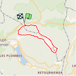
9.7 km | 14.9 km-effort
2h 30min
Yes
Trail Walking Gérardmer - gerardmer - la mauselaine . tête grauvelin . Roche boquet . croix claudé . hautes Vannes . la mauselaine  - Photo
Walking
stef789

Walking

Very easy
(1)
Gérardmer, Grand Est, Vosges, France
11.3 km | 16.2 km-effort
3h 42min
Yes
Trail Walking Xonrupt-Longemer - 23-08-17 Lac Longemer - Lispach - Photo
Walking
annefrance70

Walking

Medium
(1)
Xonrupt-Longemer, Grand Est, Vosges, France
7 km | 12.1 km-effort
2h 13min
Yes
Trail Snowshoes Le Valtin - raquettes  - Photo
Snowshoes
vathi54

Snowshoes

Very easy
(1)
Le Valtin, Grand Est, Vosges, France
6.6 km | 9.4 km-effort
3h 8min
No
Trail Walking La Bresse - Lac de Lispach  - Photo
Walking
Bruca

Walking

Easy
(1)
La Bresse, Grand Est, Vosges, France
2.1 km | 2.4 km-effort
44min
Yes
Trail Walking Xonrupt-Longemer - Le Hohneck et le sentier des roches - Du lac de Longemer au lac de Schiessrothried - Photo
Walking
tracegps

Walking

Difficult
(1)
Xonrupt-Longemer, Grand Est, Vosges, France
15.7 km | 28 km-effort
7h 0min
No
Trail Snowshoes Xonrupt-Longemer - Tour du Lispach - Longemer - Photo
Snowshoes
tracegps

Snowshoes

Medium
(2)
Xonrupt-Longemer, Grand Est, Vosges, France
3.2 km | 6.6 km-effort
2h 0min
Yes
Trail Walking Xonrupt-Longemer - Le tour du lac de longemer  - Photo
Walking
GUIDE+

Walking

Medium
Xonrupt-Longemer, Grand Est, Vosges, France
5.2 km | 6.1 km-effort
1h 22min
Yes
Trail Walking La Bresse - Lac de Lispach - Photo
Walking
GUIDE
Alizée.pee

Walking

(1)
La Bresse, Grand Est, Vosges, France
7.2 km | 9.9 km-effort
1h 56min
Yes


Close
My subscriptions