Trail Running Tarare - Tour de la montagne de Tarare - Photo

Tour de la montagne de Tarare

 tracegps
tracegps

User

© OpenStreetMap contributors
Length
Length
18.5 km
Max alt
Max alt
703 m
Uphill gradient
Uphill gradient
574 m
Km-Effort
Km-Effort  
26 km
Min alt
Min alt
403 m
Downhill gradient
Downhill gradient
577 m
Boucle
Boucle
Yes
Creation date :
2014-12-10 00:00:00.0
Updated on :
2014-12-10 00:00:00.0

(1 Reviews)

Running
Running
3h00
Difficulty : Difficult

Scan this QR Code to open this trail in the SityTrail application

FREE GPS app for hiking

Logo SityTrail SityTrail

IGN / Geographical institutes

Download SityTrail from the App Store Download SityTrail from Google Play

Logo SityTrail SityTrail World

The world is yours!

Download SityTrail from the App Store Download SityTrail from Google Play Download SityTrail on Huawei AppGallery

About

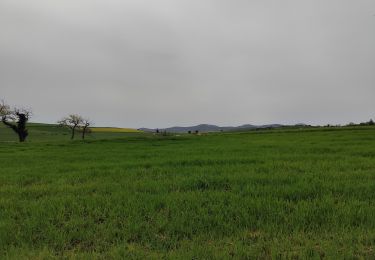
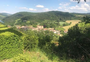
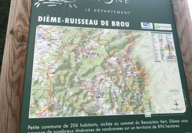
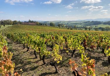
Trail Running of 18.5 km to be discovered at Auvergne-Rhône-Alpes, Rhône, Tarare. This trail is proposed by tracegps.

Description

Un très joli tour. 600m   et 19km avec des passages un peu chauds en VTT. En course à pied un très bon coureur met environ 1h45. En marche je pense qu'il faut environ 5h. Sur la fin il y a une yourte.

Elevation profile

Positioning

Country:
France
Region :
Auvergne-Rhône-Alpes
Department/Province :
Rhône
Municipality :
Tarare
Location:
Unknown
Start:(UTM)
611405 ; 5083960 (31T) N.

Comments

Please log in to post a review or rate the element


Trails nearby

Trail Walking Dième - Le Ruisseau de Brou - Photo
Walking
fernand1254

Walking

Medium
(1)
Dième, Auvergne-Rhône-Alpes, Rhône, France
11.3 km | 17.3 km-effort
3h 24min
Yes
Trail Walking Vindry-sur-Turdine - Autour de Saint loup  - Photo
Walking
dudu42

Walking

Medium
Vindry-sur-Turdine, Auvergne-Rhône-Alpes, Rhône, France
16 km | 24 km-effort
4h 18min
Yes
Trail Walking Joux - Joux (17 km - D. 625 m) - Photo
Walking
Thomasdanielle

Walking

Very difficult
Joux, Auvergne-Rhône-Alpes, Rhône, France
16.5 km | 25 km-effort
5h 38min
Yes
Trail Walking Saint-Clément-sur-Valsonne - Tour des Crets - Photo
Walking
alainsoly

Walking

Very easy
(1)
Saint-Clément-sur-Valsonne, Auvergne-Rhône-Alpes, Rhône, France
7 km | 11.1 km-effort
2h 12min
Yes
Trail Walking Dième - Dième : Le ruisseau de Brou (9 km - D. 365 m) - Photo
Walking
Thomasdanielle

Walking

Medium
Dième, Auvergne-Rhône-Alpes, Rhône, France
9.3 km | 14.2 km-effort
3h 13min
Yes
Trail Walking Dième - Dième : Le ruisseau de Brou (12 km - D. 455 m) - Photo
Walking
Thomasdanielle

Walking

Medium
Dième, Auvergne-Rhône-Alpes, Rhône, France
11.9 km | 17.9 km-effort
4h 4min
Yes
Trail Mountain bike Vindry-sur-Turdine - Dareizé cahuba 1  - Photo
Mountain bike
Cahuba

Mountain bike

Difficult
Vindry-sur-Turdine, Auvergne-Rhône-Alpes, Rhône, France
29 km | 41 km-effort
2h 52min
Yes
Trail Walking Saint-Forgeux - Randonnée de Saint Forgeux à Ronzière - Photo
Walking
tracegps

Walking

Difficult
Saint-Forgeux, Auvergne-Rhône-Alpes, Rhône, France
11.2 km | 16.8 km-effort
3h 0min
Yes
Trail On foot Vindry-sur-Turdine - Saint loup  - Photo
On foot
hearly

On foot

Medium
Vindry-sur-Turdine, Auvergne-Rhône-Alpes, Rhône, France
15.6 km | 23 km-effort
5h 17min
Yes


Close
My subscriptions