![](/images/other/stat-length.png)
![Trail Walking Vissec - Gorges de la Vis - Le Moulin de la Foux - Vissec - Photo](https://media.geolcdn.com/t/1900/400/ext.pjpeg?maxdim=2&url=https%3A%2F%2Fstatic1.geolcdn.com%2Fsiteimages%2Fupload%2Ffiles%2F1553511878bg_sport_marche.png)
Gorges de la Vis - Le Moulin de la Foux - Vissec
tracegps
User
![Length](/images/other/stat-length.png)
Length
22 km
![Max alt](https://static1.geolcdn.com/siteimages/upload/files/1508320355ic_sort_altitude_max_24dp.png)
Max alt
719 m
![Uphill gradient](https://static1.geolcdn.com/siteimages/upload/files/1508320355ic_sort_den_pos_24dp.png)
Uphill gradient
713 m
![Km-Effort](/images/other/stat-length.png)
Km-Effort
31 km
![Min alt](https://static1.geolcdn.com/siteimages/upload/files/1508320355ic_sort_altitude_min_24dp.png)
Min alt
329 m
![Downhill gradient](https://static1.geolcdn.com/siteimages/upload/files/1508320355ic_sort_den_neg_24dp.png)
Downhill gradient
717 m
![Boucle](https://static1.geolcdn.com/siteimages/upload/files/16400158638029165_repeat_loop_refresh_sync_direction_icon.png)
Boucle
Yes
Creation date :
2014-12-10 00:00:00.0
Updated on :
2014-12-10 00:00:00.0
![Walking](https://static1.geolcdn.com/sitytour/trail-icons/101.png)
6h30
Difficulty : Difficult
![Scan this QR Code to open this trail in the SityTrail application](https://capi.geolives.com/qq0zvz2zws4bq2lad0pu/sitytour/trails/106720/qr.png?size=200)
FREE GPS app for hiking
About
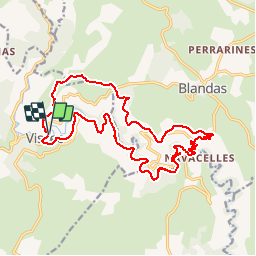
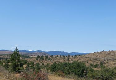
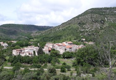
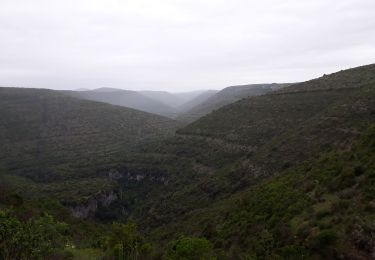
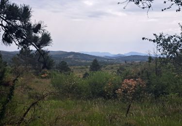
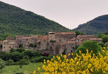
Trail Walking of 22 km to be discovered at Occitania, Gard, Vissec. This trail is proposed by tracegps.
Description
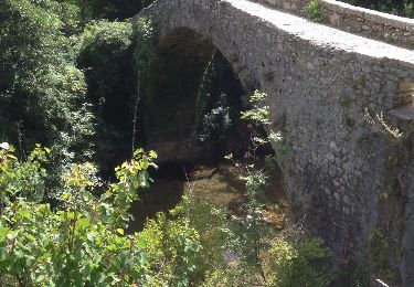
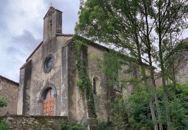
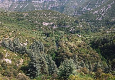
Cette randonnée est difficile en raison de sa longueur, plus de 22 km, et de la remontée du cirque de Navacelles pour atteindre le Causse. Voir les photos ci dessus.
Positioning
Country:
France
Region :
Occitania
Department/Province :
Gard
Municipality :
Vissec
Location:
Unknown
Start:(Dec)
Start:(UTM)
536937 ; 4860906 (31T) N.
Comments
Trails nearby
![Trail Walking Saint-Maurice-Navacelles - cirque de Navacelles - Photo](https://media.geolcdn.com/t/375/260/ext.jpg?maxdim=2&url=https%3A%2F%2Fservices.sitytrail.com%2FGeolivesWS%2FDownloadMedia.ashx%3FTrailID%3D331316%26Media%3D20140805152414.jpg)
![Walking Walking](https://static1.geolcdn.com/sitytour/trail-icons/101.png)
cirque de Navacelles
Walking
Medium
(1)
Saint-Maurice-Navacelles,
Occitania,
Hérault,
France
![](/images/other/stat-length.png)
10.6 km | 14.5 km-effort
3h 17min
![](https://static1.geolcdn.com/siteimages/upload/files/16400158638029165_repeat_loop_refresh_sync_direction_icon.png)
Yes
![Trail On foot Saint-Maurice-Navacelles - Navacelles Vissec par le chemin du facteur - Photo](https://media.geolcdn.com/t/375/260/ext.jpg?maxdim=2&url=https%3A%2F%2Fmedia.geolcdn.com%2Ff%2F5eb51299-e303-4e2d-9d78-ac9fc254c62c.jpeg)
![On foot On foot](https://static1.geolcdn.com/sitytour/trail-icons/100.png)
Navacelles Vissec par le chemin du facteur
On foot
Medium
Saint-Maurice-Navacelles,
Occitania,
Hérault,
France
![](/images/other/stat-length.png)
17.7 km | 25 km-effort
5h 46min
![](https://static1.geolcdn.com/siteimages/upload/files/16400158638029165_repeat_loop_refresh_sync_direction_icon.png)
Yes
![Trail On foot Blandas - Randonnée Cirque de Navacelles - Causse de Blandas - Vissec - Moulin de la Foux - Photo](https://media.geolcdn.com/t/375/260/ext.jpg?maxdim=2&url=https%3A%2F%2Fmedia.geolcdn.com%2Ff%2F8ddb3d2c-f886-47a1-a994-79ae500f0ce8.jpeg)
![On foot On foot](https://static1.geolcdn.com/sitytour/trail-icons/100.png)
Randonnée Cirque de Navacelles - Causse de Blandas - Vissec - Moulin de la Foux
On foot
Medium
Blandas,
Occitania,
Gard,
France
![](/images/other/stat-length.png)
19 km | 26 km-effort
6h 0min
![](https://static1.geolcdn.com/siteimages/upload/files/16400158638029165_repeat_loop_refresh_sync_direction_icon.png)
Yes
![Trail Walking Blandas - Causse de Blandas et Vallée de la Vis - Photo](https://media.geolcdn.com/t/375/260/ext.jpg?maxdim=2&url=https%3A%2F%2Fmedia.geolcdn.com%2Ff%2F63d6e02c-c419-4b36-9d67-d9ec414c30bc.jpg)
![Walking Walking](https://static1.geolcdn.com/sitytour/trail-icons/101.png)
Causse de Blandas et Vallée de la Vis
Walking
Difficult
Blandas,
Occitania,
Gard,
France
![](/images/other/stat-length.png)
19.1 km | 27 km-effort
6h 27min
![](https://static1.geolcdn.com/siteimages/upload/files/16400158638029165_repeat_loop_refresh_sync_direction_icon.png)
Yes
![Trail Walking Blandas - Vissec / Moulin de la Foux - Photo](https://media.geolcdn.com/t/375/260/ext.jpg?maxdim=2&url=https%3A%2F%2Fmedia.geolcdn.com%2Ff%2F10a13c13-90e1-488e-8e53-bc3d65b1bc36.jpg)
![Walking Walking](https://static1.geolcdn.com/sitytour/trail-icons/101.png)
Vissec / Moulin de la Foux
Walking
Medium
Blandas,
Occitania,
Gard,
France
![](/images/other/stat-length.png)
12.9 km | 19.4 km-effort
3h 41min
![](https://static1.geolcdn.com/siteimages/upload/files/16400158638029165_repeat_loop_refresh_sync_direction_icon.png)
Yes
![Trail Walking Blandas - Bois de calot rouge - Photo](https://media.geolcdn.com/t/375/260/ext.jpg?maxdim=2&url=https%3A%2F%2Fmedia.geolcdn.com%2Ff%2Fa9a713a3-ac0f-45b3-9482-9c5a24bfa783.jpg)
![Walking Walking](https://static1.geolcdn.com/sitytour/trail-icons/101.png)
Bois de calot rouge
Walking
Medium
Blandas,
Occitania,
Gard,
France
![](/images/other/stat-length.png)
11 km | 15.5 km-effort
2h 58min
![](https://static1.geolcdn.com/siteimages/upload/files/16400158638029165_repeat_loop_refresh_sync_direction_icon.png)
Yes
![Trail Walking Blandas - Sentier du Belvédère de Blandas 2 - Photo](https://media.geolcdn.com/t/375/260/ext.jpg?maxdim=2&url=https%3A%2F%2Fstatic1.geolcdn.com%2Fsiteimages%2Fupload%2Ffiles%2F1553511878bg_sport_marche.png)
![Walking Walking](https://static1.geolcdn.com/sitytour/trail-icons/101.png)
Sentier du Belvédère de Blandas 2
Walking
Medium
(1)
Blandas,
Occitania,
Gard,
France
![](/images/other/stat-length.png)
11 km | 16.4 km-effort
3h 38min
![](https://static1.geolcdn.com/siteimages/upload/files/16400158638029165_repeat_loop_refresh_sync_direction_icon.png)
Yes
![Trail Walking Blandas - Blandas - Photo](https://media.geolcdn.com/t/375/260/ext.jpg?maxdim=2&url=https%3A%2F%2Fmedia.geolcdn.com%2Ff%2Fedaf02ae-e2d8-401e-a5bc-a8ab7a7adc3c.jpg)
![Walking Walking](https://static1.geolcdn.com/sitytour/trail-icons/101.png)
![Trail Walking Vissec - Vissec à Navacelle - Photo](https://media.geolcdn.com/t/375/260/ext.jpg?maxdim=2&url=https%3A%2F%2Fmedia.geolcdn.com%2Ff%2F537f5131-f938-4853-a1e4-0c864f3197d3.jpg)
![Walking Walking](https://static1.geolcdn.com/sitytour/trail-icons/101.png)
Vissec à Navacelle
Walking
Difficult
Vissec,
Occitania,
Gard,
France
![](/images/other/stat-length.png)
19.8 km | 28 km-effort
6h 29min
![](https://static1.geolcdn.com/siteimages/upload/files/16400158638029165_repeat_loop_refresh_sync_direction_icon.png)
Yes