Randonnée des 5 lacs - Lacs de Forclaz

tracegps
User

Length
24 km

Max alt
2858 m

Uphill gradient
1643 m
Km-Effort
45 km

Min alt
1329 m

Downhill gradient
1663 m
Boucle
Yes
Creation date :
2014-12-10 00:00:00.0
Updated on :
2014-12-10 00:00:00.0
8h00
Difficulty : Very difficult

FREE GPS app for hiking
 SityTrail
IGN / Geographical institutes
SityTrail Plus
The world is yours!
About
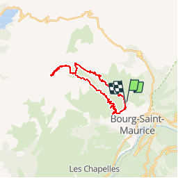
Trail Walking of 24 km to be discovered at Auvergne-Rhône-Alpes, Savoy, Bourg-Saint-Maurice. This trail is proposed by tracegps.
Photos


Positioning
Country:
France
Region :
Auvergne-Rhône-Alpes
Department/Province :
Savoy
Municipality :
Bourg-Saint-Maurice
Location:
Unknown
Start:(Dec)
Start:(UTM)
325453 ; 5055980 (32T) N.
Comments