Trail Mountain bike Alissas - Traversée des Grads - Alissas - Photo

Traversée des Grads - Alissas

 tracegps
tracegps

User

© OpenStreetMap contributors
Length
Length
26 km
Max alt
Max alt
445 m
Uphill gradient
Uphill gradient
715 m
Km-Effort
Km-Effort  
35 km
Min alt
Min alt
153 m
Downhill gradient
Downhill gradient
715 m
Boucle
Boucle
Yes
Creation date :
2014-12-10 00:00:00.0
Updated on :
2014-12-10 00:00:00.0

(1 Reviews)

Mountain bike
Mountain bike
2h30
Difficulty : Difficult

Scan this QR Code to open this trail in the SityTrail application

FREE GPS app for hiking

Logo SityTrail SityTrail

IGN / Geographical institutes

Download SityTrail from the App Store Download SityTrail from Google Play

Logo SityTrail SityTrail World

The world is yours!

Download SityTrail from the App Store Download SityTrail from Google Play Download SityTrail on Huawei AppGallery

About

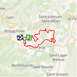
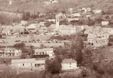
Trail Mountain bike of 26 km to be discovered at Auvergne-Rhône-Alpes, Ardèche, Alissas. This trail is proposed by tracegps.

Description

Le circuit débute sur le parking du terrain de tennis pour monter rapidement au sommet de la Crête des Grads. Au menu pas mal de cailloux, mais des descentes en single plutôt sympas. Attention toutefois à bien suivre le tracé exact pour ne pas faire l'impasse sur des descentes peu connues du grand public. Bon ride.

Elevation profile

Positioning

Country:
France
Region :
Auvergne-Rhône-Alpes
Department/Province :
Ardèche
Municipality :
Alissas
Location:
Unknown
Start:(UTM)
629318 ; 4952463 (31T) N.

Comments

Please log in to post a review or rate the element


Trails nearby

Trail Walking Coux - Coux Serre Gruas 19km - Photo
Walking
GUIDE
thonyc

Walking

Medium
Coux, Auvergne-Rhône-Alpes, Ardèche, France
19.4 km | 29 km-effort
5h 25min
Yes
Trail Walking Coux - Jaubernie - Photo
Walking
OscarMa

Walking

Easy
(2)
Coux, Auvergne-Rhône-Alpes, Ardèche, France
14.8 km | 22 km-effort
4h 41min
Yes
Trail Walking Coux - w-frankrijk-wandelroute-coux-ardeche - Photo
Walking
gpstracks

Walking

Very easy
(1)
Coux, Auvergne-Rhône-Alpes, Ardèche, France
5.8 km | 9.3 km-effort
Unknown
Yes
Trail Walking Flaviac - Flaviac Serre de l'Eglise 15km - Photo
Walking
GUIDE
thonyc

Walking

Medium
Flaviac, Auvergne-Rhône-Alpes, Ardèche, France
14.5 km | 23 km-effort
5h 0min
Yes
Trail Walking Chomérac - Chomérac les 2 vallées 14km - Photo
Walking
GUIDE
thonyc

Walking

Medium
Chomérac, Auvergne-Rhône-Alpes, Ardèche, France
13.8 km | 21 km-effort
4h 40min
Yes
Trail Walking Coux - Coux 10km - Photo
Walking
GUIDE
thonyc

Walking

Medium
Coux, Auvergne-Rhône-Alpes, Ardèche, France
10.4 km | 16.1 km-effort
3h 0min
Yes
Trail Walking Lyas - 07 privas Livier zel - Photo
Walking
himba26100

Walking

Medium
Lyas, Auvergne-Rhône-Alpes, Ardèche, France
18.1 km | 28 km-effort
6h 46min
Yes
Trail Walking Alissas - 07 Alissas rochessauve zel 23.11.22 - Photo
Walking
himba26100

Walking

Easy
Alissas, Auvergne-Rhône-Alpes, Ardèche, France
15.3 km | 22 km-effort
6h 5min
Yes
Trail Walking Saint-Bauzile - Saint bauzille  - Photo
Walking
Vero7684

Walking

Medium
Saint-Bauzile, Auvergne-Rhône-Alpes, Ardèche, France
18.4 km | 26 km-effort
5h 0min
Yes


Close
My subscriptions