Trail Walking Sénezergues - Les Gorges du Don - Senezergues - Photo

Les Gorges du Don - Senezergues

 tracegps
tracegps

User

© OpenStreetMap contributors
Length
Length
5.1 km
Max alt
Max alt
546 m
Uphill gradient
Uphill gradient
300 m
Km-Effort
Km-Effort  
9.1 km
Min alt
Min alt
267 m
Downhill gradient
Downhill gradient
294 m
Boucle
Boucle
Yes
Creation date :
2014-12-10 00:00:00.0
Updated on :
2014-12-10 00:00:00.0

(0 Reviews)

Walking
Walking
2h30
Difficulty : Very difficult

Scan this QR Code to open this trail in the SityTrail application

FREE GPS app for hiking

Logo SityTrail SityTrail

IGN / Geographical institutes

Download SityTrail from the App Store Download SityTrail from Google Play

Logo SityTrail SityTrail World

The world is yours!

Download SityTrail from the App Store Download SityTrail from Google Play Download SityTrail on Huawei AppGallery

About

Trail Walking of 5.1 km to be discovered at Auvergne-Rhône-Alpes, Cantal, Sénezergues. This trail is proposed by tracegps.

Description

Départ de l'ancienne poterie du Don (possibilité de de stationner sur le parking). Direction Senezergues pour plonger sur le premier chemin sur votre gauche. Dans les gorges, vous trouverez des flèches roses fluo pour passer les gorges (4 à 5 passages accidentés). Se munir de bonnes chaussures de marche et d'une corde (par sécurisation dans les descentes). Ce tracé est fortement déconseillé hors période estivale et par temps orageux. Il est possible de descendre la totalité des gorges jusqu'au moulin d'Auze (prévoir un véhicule pour le retour).

Elevation profile

Positioning

Country:
France
Region :
Auvergne-Rhône-Alpes
Department/Province :
Cantal
Municipality :
Sénezergues
Location:
Unknown
Start:(UTM)
453937 ; 4947894 (31T) N.

Trails nearby

Trail Walking Sénezergues - promenade de la noix à Senezergues - Photo
Walking
alainlissac

Walking

Medium
(2)
Sénezergues, Auvergne-Rhône-Alpes, Cantal, France
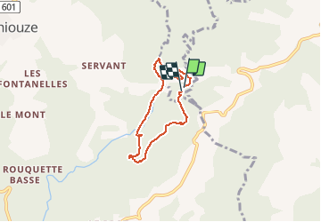
10.9 km | 15.2 km-effort
3h 27min
Yes
Trail Mountain bike Puycapel - Dans les bois de Calvinet - La Roubine - Photo
Mountain bike
tracegps

Mountain bike

Medium
(1)
Puycapel, Auvergne-Rhône-Alpes, Cantal, France
24 km | 32 km-effort
2h 30min
Yes
Trail Walking Cassaniouze - cassaniouze st projet  - Photo
Walking
Sandrine 15

Walking

Very difficult
Cassaniouze, Auvergne-Rhône-Alpes, Cantal, France
13.6 km | 22 km-effort
2h 39min
Yes
Trail Walking Cassaniouze - vinzelle  - Photo
Walking
Delmasjacques

Walking

Very easy
Cassaniouze, Auvergne-Rhône-Alpes, Cantal, France
6.2 km | 10.9 km-effort
3h 34min
Yes
Trail Walking Cassaniouze - cassaniouze st projet - Photo
Walking
yves12

Walking

Medium
Cassaniouze, Auvergne-Rhône-Alpes, Cantal, France
15.2 km | 24 km-effort
3h 52min
Yes
Trail Walking Cassaniouze - Cassaniouze - St Projet - Le chateau de Roquemaurel - Photo
Walking
tracegps

Walking

Difficult
Cassaniouze, Auvergne-Rhône-Alpes, Cantal, France
15.6 km | 26 km-effort
4h 0min
Yes
Trail Walking Cassaniouze - St Projet 12 - Photo
Walking
gcournac

Walking

Very difficult
Cassaniouze, Auvergne-Rhône-Alpes, Cantal, France
15.8 km | 26 km-effort
4h 55min
Yes
Trail On foot Conques-en-Rouergue - La Cassanie - Photo
On foot
PRO

On foot

Easy
Conques-en-Rouergue, Occitania, Aveyron, France
4 km | 5.4 km-effort
1h 13min
No
Trail Walking Puycapel - la rouquette - Photo
Walking
Danielle Lissac

Walking

Medium
Puycapel, Auvergne-Rhône-Alpes, Cantal, France
8.5 km | 10.7 km-effort
1h 28min
Yes


Close
My subscriptions