Trail Walking Rieux - Rieux - Le Roc et l'eau - Photo

Rieux - Le Roc et l'eau

 tracegps
tracegps

User

© OpenStreetMap contributors
Length
Length
9.7 km
Max alt
Max alt
109 m
Uphill gradient
Uphill gradient
207 m
Km-Effort
Km-Effort  
12.5 km
Min alt
Min alt
27 m
Downhill gradient
Downhill gradient
218 m
Boucle
Boucle
No
Creation date :
2014-12-10 00:00:00.0
Updated on :
2014-12-10 00:00:00.0

(0 Reviews)

Walking
Walking
2h00
Difficulty : Medium

Scan this QR Code to open this trail in the SityTrail application

FREE GPS app for hiking

Logo SityTrail SityTrail

IGN / Geographical institutes

Download SityTrail from the App Store Download SityTrail from Google Play

Logo SityTrail SityTrail World

The world is yours!

Download SityTrail from the App Store Download SityTrail from Google Play Download SityTrail on Huawei AppGallery

About

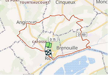
Trail Walking of 9.7 km to be discovered at Hauts-de-France, Oise, Rieux. This trail is proposed by tracegps.

Description

Distance 9Km - départ de Rieux, village situé face à la forêt d 'Halatte, entouré de coteaux surmonté de crêtes boisées, au bord du Rhoni gros ruisseau venant de Verderonne et se jetant dans l'Oise à 100m en amont de la gare de Rieux.

Elevation profile

Photos

Positioning

Country:
France
Region :
Hauts-de-France
Department/Province :
Oise
Municipality :
Rieux
Location:
Unknown
Start:(UTM)
464772 ; 5461017 (31U) N.

Trails nearby

Trail Walking Beaurepaire - La mare aux oiseaux - Beaurepaire - Photo
Walking
tracegps

Walking

Medium
(1)
Beaurepaire, Hauts-de-France, Oise, France
8.4 km | 10.2 km-effort
2h 10min
Yes
Trail Walking Verderonne - verderonne - Photo
Walking
bertrandgeffroy

Walking

Medium
(1)
Verderonne, Hauts-de-France, Oise, France
23 km | 27 km-effort
5h 0min
Yes
Trail Walking Verneuil-en-Halatte - 2022-01-30 balade nous samy nouveau grand tour départ vers marronniers retour fond ste geneviève  - Photo
Walking
rolandmonjean

Walking

Easy
Verneuil-en-Halatte, Hauts-de-France, Oise, France
9.8 km | 11.8 km-effort
3h 13min
Yes
Trail Walking Verderonne - Randonnée de Rosoy à Verderonne - Photo
Walking
tracegps

Walking

Medium
Verderonne, Hauts-de-France, Oise, France
8.3 km | 9.9 km-effort
1h 30min
Yes
Trail sport Monchy-Saint-Éloi - 2022-09-28_13h36m37_<CAC9XJQ5buBJim13UVmX+3WM3tvG2H9PncH-espriqxQdtYHG3Q@mailgmailcom>_chedeville-9kmsgpxchedeville-9kms - Photo
sport
Marc ROUSSELOT

sport

Very easy
Monchy-Saint-Éloi, Hauts-de-France, Oise, France
8 km | 9.5 km-effort
Unknown
Yes
Trail Walking Verneuil-en-Halatte - 2022-02-14 balade nous samy petite boucle 1h fond ste geneviève retour marronnier verneuil - Photo
Walking
rolandmonjean

Walking

Easy
Verneuil-en-Halatte, Hauts-de-France, Oise, France
4.4 km | 5.4 km-effort
1h 33min
Yes
Trail Walking Verneuil-en-Halatte - 2022-02-09 balade nous samy 3ème nouvelle boucle verneuil champ haut montlaville direction fleurines retour fond ste geneviève  - Photo
Walking
rolandmonjean

Walking

Easy
Verneuil-en-Halatte, Hauts-de-France, Oise, France
7.6 km | 8.4 km-effort
2h 27min
No
Trail Walking Verneuil-en-Halatte - Marche après-midi- VERNEUIL EN HALATTE  - Photo
Walking
Marc ROUSSELOT

Walking

Difficult
Verneuil-en-Halatte, Hauts-de-France, Oise, France
10.3 km | 12 km-effort
1h 58min
Yes
Trail Walking Verneuil-en-Halatte - 2022- balade nous samy verneuil circuit par ruines château erreur - Photo
Walking
rolandmonjean

Walking

Very easy
Verneuil-en-Halatte, Hauts-de-France, Oise, France
4.8 km | 6 km-effort
1h 58min
Yes


Close
My subscriptions