Trail Walking Verneuil-en-Halatte - 2022-01-30 balade nous samy nouveau grand tour départ vers marronniers retour fond ste geneviève  - Photo

2022-01-30 balade nous samy nouveau grand tour départ vers marronniers retour fond ste geneviève

© OpenStreetMap contributors
Length
Length
9.8 km
Max alt
Max alt
123 m
Uphill gradient
Uphill gradient
148 m
Km-Effort
Km-Effort  
11.8 km
Min alt
Min alt
39 m
Downhill gradient
Downhill gradient
143 m
Boucle
Boucle
Yes
Creation date :
2022-01-30 13:44:51.921
Updated on :
2022-01-30 16:59:19.891

(0 Reviews)

Walking
Walking
3h13
Difficulty : Easy

Scan this QR Code to open this trail in the SityTrail application

FREE GPS app for hiking

Logo SityTrail SityTrail

IGN / Geographical institutes

Download SityTrail from the App Store Download SityTrail from Google Play

Logo SityTrail SityTrail World

The world is yours!

Download SityTrail from the App Store Download SityTrail from Google Play Download SityTrail on Huawei AppGallery

About

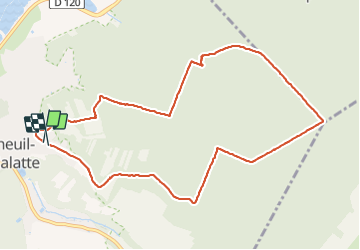
Trail Walking of 9.8 km to be discovered at Hauts-de-France, Oise, Verneuil-en-Halatte. This trail is proposed by rolandmonjean.

Description

balade nous samy nouveau tour départ marronniers retour fond ste Geneviève

Elevation profile

Photos

Positioning

Country:
France
Region :
Hauts-de-France
Department/Province :
Oise
Municipality :
Verneuil-en-Halatte
Location:
Unknown
Start:(UTM)
465518 ; 5458125 (31U) N.

Trails nearby

Trail Walking Beaurepaire - La mare aux oiseaux - Beaurepaire - Photo
Walking
tracegps

Walking

Medium
(1)
Beaurepaire, Hauts-de-France, Oise, France
8.4 km | 10.2 km-effort
2h 10min
Yes
Trail Walking Fleurines - Fleurines Grand parcours - Photo
Walking
CC.RIDER

Walking

Easy
(1)
Fleurines, Hauts-de-France, Oise, France
20 km | 24 km-effort
5h 8min
Yes
Trail Walking Fleurines - Fleurines_StChristophe_12,7 km_Trace GPS - Photo
Walking
Pousscailleux

Walking

Medium
(1)
Fleurines, Hauts-de-France, Oise, France
12.7 km | 15.6 km-effort
2h 42min
Yes
Trail Walking Senlis - SM_FLEURINE (Poteau Belle Croix) - Photo
Walking
GR77LP

Walking

Difficult
Senlis, Hauts-de-France, Oise, France
8.6 km | 10.5 km-effort
2h 47min
Yes
Trail Hybrid bike Pont-Sainte-Maxence - halte menhirs d' iderolles - Photo
Hybrid bike
gilbertdu60

Hybrid bike

Easy
Pont-Sainte-Maxence, Hauts-de-France, Oise, France
17.1 km | 19.4 km-effort
1h 59min
No
Trail Walking Aumont-en-Halatte - 2019-06-11 13:14:39 - Photo
Walking
boularand

Walking

Difficult
Aumont-en-Halatte, Hauts-de-France, Oise, France
13.7 km | 16.2 km-effort
3h 32min
Yes
Trail Walking Rieux - Rieux - Le Roc et l'eau - Photo
Walking
tracegps

Walking

Medium
Rieux, Hauts-de-France, Oise, France
9.7 km | 12.5 km-effort
2h 0min
No
Trail sport Monchy-Saint-Éloi - 2022-09-28_13h36m37_<CAC9XJQ5buBJim13UVmX+3WM3tvG2H9PncH-espriqxQdtYHG3Q@mailgmailcom>_chedeville-9kmsgpxchedeville-9kms - Photo
sport
Marc ROUSSELOT

sport

Very easy
Monchy-Saint-Éloi, Hauts-de-France, Oise, France
8 km | 9.5 km-effort
Unknown
Yes
Trail Walking Fleurines - SityTrail - PN_FLEURINES(ForetHalatte)_14.8Km - Photo
Walking
mariejochat

Walking

Difficult
(1)
Fleurines, Hauts-de-France, Oise, France
15.1 km | 18 km-effort
4h 5min
Yes


Close
My subscriptions