Trail Running Châteauneuf-Miravail - Lange - Lange par le Tréboux - Photo
 tracegps
tracegps

User

© OpenStreetMap contributors
Length
Length
16.6 km
Max alt
Max alt
1531 m
Uphill gradient
Uphill gradient
988 m
Km-Effort
Km-Effort  
30 km
Min alt
Min alt
717 m
Downhill gradient
Downhill gradient
994 m
Boucle
Boucle
Yes
Creation date :
2014-12-10 00:00:00.0
Updated on :
2014-12-10 00:00:00.0

(0 Reviews)

Running
Running
3h00
Difficulty : Difficult

Scan this QR Code to open this trail in the SityTrail application

FREE GPS app for hiking

Logo SityTrail SityTrail

IGN / Geographical institutes

Download SityTrail from the App Store Download SityTrail from Google Play

Logo SityTrail SityTrail World

The world is yours!

Download SityTrail from the App Store Download SityTrail from Google Play Download SityTrail on Huawei AppGallery

About

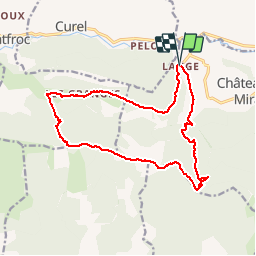
Trail Running of 16.6 km to be discovered at Provence-Alpes-Côte d'Azur, Alpes-de-Haute-Provence, Châteauneuf-Miravail. This trail is proposed by tracegps.

Description

Départ de Lange. Ce circuit qui emprunte le GR de Pays jusqu'au col de la Roche est le parcours, à l'envers, du 18 km du Trail "La Belle à Lure" organisé par le CdF de Châteauneuf-Miravail. La montée jusqu'au Col de la Roche est ardue mais toute en sous bois. Joli point de vue au sommet du Tréboux. La descente par la crête jusqu'au Col de St Vincent est magnifique.

Elevation profile

Photos

Positioning

Country:
France
Region :
Provence-Alpes-Côte d'Azur
Department/Province :
Alpes-de-Haute-Provence
Municipality :
Châteauneuf-Miravail
Location:
Unknown
Start:(Dec)
Start:(UTM)
715847 ; 4894092 (31T) N.

Trails nearby

Trail Walking Saint-Vincent-sur-Jabron - Traversée de la Montagne de Mare depuis Aubard - Photo
Walking
tracegps

Walking

Easy
(1)
Saint-Vincent-sur-Jabron, Provence-Alpes-Côte d'Azur, Alpes-de-Haute-Provence, France
13.3 km | 23 km-effort
5h 45min
Yes
Trail Walking Éourres - mare et pied du mulet - Photo
Walking
y39c43l

Walking

Easy
(1)
Éourres, Provence-Alpes-Côte d'Azur, Hautes-Alpes, France
12.2 km | 23 km-effort
5h 47min
No
Trail Walking Saint-Vincent-sur-Jabron - Crête Montagne de Mare - Photo
Walking
PapouBertrand

Walking

Very difficult
Saint-Vincent-sur-Jabron, Provence-Alpes-Côte d'Azur, Alpes-de-Haute-Provence, France
14.8 km | 25 km-effort
5h 44min
Yes
Trail Walking Saint-Vincent-sur-Jabron - SAINT VINCENT DU JABRON.  Aubard,  col de Verdun , le pied du mulet o l m s  - Photo
Walking
RobinMicheline

Walking

Medium
Saint-Vincent-sur-Jabron, Provence-Alpes-Côte d'Azur, Alpes-de-Haute-Provence, France
13.3 km | 23 km-effort
3h 48min
Yes
Trail Walking Saint-Vincent-sur-Jabron - SAINT VINCENT SUR JABRON. Pas de Parandier  ,montagne S Michel o n - Photo
Walking
RobinMicheline

Walking

Medium
Saint-Vincent-sur-Jabron, Provence-Alpes-Côte d'Azur, Alpes-de-Haute-Provence, France
14.4 km | 23 km-effort
4h 13min
Yes
Trail Running Curel - Les Chaux - Curel  - Photo
Running
tracegps

Running

Difficult
Curel, Provence-Alpes-Côte d'Azur, Alpes-de-Haute-Provence, France
8.5 km | 16.2 km-effort
1h 21min
Yes
Trail Walking Curel - Les Chaux - Curel  - Photo
Walking
tracegps

Walking

Medium
Curel, Provence-Alpes-Côte d'Azur, Alpes-de-Haute-Provence, France
8.5 km | 16.2 km-effort
2h 30min
Yes
Trail Running Châteauneuf-Miravail - Lange - Lange par le Contras - Photo
Running
tracegps

Running

Very difficult
Châteauneuf-Miravail, Provence-Alpes-Côte d'Azur, Alpes-de-Haute-Provence, France
21 km | 36 km-effort
3h 0min
Yes
Trail Walking Saint-Vincent-sur-Jabron - SAINT VINCENT DU JABRON . Aubard ,  vieux Curel  , chateau des Graves o l s  - Photo
Walking
RobinMicheline

Walking

Difficult
(1)
Saint-Vincent-sur-Jabron, Provence-Alpes-Côte d'Azur, Alpes-de-Haute-Provence, France
16.1 km | 24 km-effort
4h 53min
Yes


Close
My subscriptions