


Mont St Héléna

nandaf
User
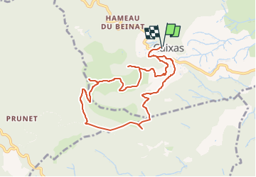

Length
9.8 km

Max alt
772 m

Uphill gradient
444 m
Km-Effort
15.8 km

Min alt
377 m

Downhill gradient
446 m
Boucle
Yes
Creation date :
2019-09-17 06:33:38.707
Updated on :
2024-02-27 18:12:08.139
3h00
Difficulty : Easy

FREE GPS app for hiking
 SityTrail
IGN / Geographical institutes
SityTrail Plus
The world is yours!
About
Trail Walking of 9.8 km to be discovered at Occitania, Pyrénées-Orientales, Caixas. This trail is proposed by nandaf.
Description
Au départ du cimetière de Caixas
Positioning
Country:
France
Region :
Occitania
Department/Province :
Pyrénées-Orientales
Municipality :
Caixas
Location:
Unknown
Start:(Dec)
Start:(UTM)
473873 ; 4714569 (31T) N.
Comments