


cabane de chéruePIR

LouisROGER
User GUIDE
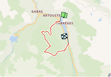

Length
8.7 km

Max alt
2183 m

Uphill gradient
908 m
Km-Effort
21 km

Min alt
1263 m

Downhill gradient
920 m
Boucle
No
Creation date :
2019-01-15 18:50:39.464
Updated on :
2019-01-15 18:50:39.464
4h02
Difficulty : Unknown

FREE GPS app for hiking
 SityTrail
IGN / Geographical institutes
SityTrail Plus
The world is yours!
About
Trail Walking of 8.7 km to be discovered at New Aquitaine, Pyrénées-Atlantiques, Laruns. This trail is proposed by LouisROGER.
Positioning
Country:
France
Region :
New Aquitaine
Department/Province :
Pyrénées-Atlantiques
Municipality :
Laruns
Location:
Unknown
Start:(Dec)
Start:(UTM)
712148 ; 4750864 (30T) N.
Comments