Trail Mountain bike Carantilly - Cametours par Montpinchon - Photo

Cametours par Montpinchon

 tracegps
tracegps

User

© OpenStreetMap contributors
Length
Length
48 km
Max alt
Max alt
148 m
Uphill gradient
Uphill gradient
694 m
Km-Effort
Km-Effort  
57 km
Min alt
Min alt
38 m
Downhill gradient
Downhill gradient
690 m
Boucle
Boucle
No
Creation date :
2014-12-10 00:00:00.0
Updated on :
2014-12-10 00:00:00.0

(0 Reviews)

Mountain bike
Mountain bike
3h30
Difficulty : Difficult

Scan this QR Code to open this trail in the SityTrail application

FREE GPS app for hiking

Logo SityTrail SityTrail

IGN / Geographical institutes

Download SityTrail from the App Store Download SityTrail from Google Play

Logo SityTrail SityTrail World

The world is yours!

Download SityTrail from the App Store Download SityTrail from Google Play Download SityTrail on Huawei AppGallery

About

Trail Mountain bike of 48 km to be discovered at Normandy, Manche, Carantilly. This trail is proposed by tracegps.

Description

Circuit agréable qui emprunte de nombreux chemins et qui monte à Montpinchon par le GR. Quelques descentes sympas et des passages par des ruisseaux. Une partie du parcours passe par un circuit balisé de Cerisy la Salle.

Elevation profile

Positioning

Country:
France
Region :
Normandy
Department/Province :
Manche
Municipality :
Carantilly
Location:
Unknown
Start:(UTM)
626390 ; 5436577 (30U) N.

Trails nearby

Trail Mountain bike Cerisy-la-Salle - Cerisy La Salle - Photo
Mountain bike
stephbab1

Mountain bike

Medium
Cerisy-la-Salle, Normandy, Manche, France
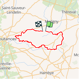
9 km | 11.8 km-effort
59min
Yes
Trail Walking Marigny-Le-Lozon - Marigny - Photo
Walking
Roulland

Walking

Very easy
Marigny-Le-Lozon, Normandy, Manche, France
11.3 km | 13.4 km-effort
2h 18min
Yes
Trail Equestrian Le Lorey - le lorey - Photo
Equestrian
pleviautre

Equestrian

Very easy
Le Lorey, Normandy, Manche, France
9.6 km | 10.8 km-effort
1h 37min
Yes
Trail Other activity Montpinchon - 18mai2013 - Photo
Other activity
pleviautre

Other activity

Very easy
Montpinchon, Normandy, Manche, France
23 km | 28 km-effort
3h 19min
No
Trail Mountain bike Cametours - VTT au départ de Cametours - Photo
Mountain bike
tracegps

Mountain bike

Difficult
Cametours, Normandy, Manche, France
38 km | 46 km-effort
3h 0min
No
Trail Walking Marigny-Le-Lozon - Marigny le lozon - Photo
Walking
Yvon59

Walking

Medium
Marigny-Le-Lozon, Normandy, Manche, France
10.3 km | 11.7 km-effort
2h 35min
Yes
Trail Walking Le Mesnil-Amey - Le Mesnil Hamey - Photo
Walking
Bubux

Walking

Medium
Le Mesnil-Amey, Normandy, Manche, France
8.3 km | 9.9 km-effort
2h 41min
No
Trail Walking Marigny-Le-Lozon - MARIGNY 23K - Photo
Walking
UDGI54

Walking

Very difficult
Marigny-Le-Lozon, Normandy, Manche, France
23 km | 28 km-effort
6h 16min
Yes
Trail Mountain bike Quibou - Le long de la soûlles - Photo
Mountain bike
manuel14

Mountain bike

Quibou, Normandy, Manche, France
29 km | 34 km-effort
2h 4min
No


Close
My subscriptions