Trail Running Digne-les-Bains -  Trail du Cousson - Digne les Bains - Photo
 tracegps
tracegps

User

© OpenStreetMap contributors
Length
Length
17.4 km
Max alt
Max alt
1492 m
Uphill gradient
Uphill gradient
1022 m
Km-Effort
Km-Effort  
31 km
Min alt
Min alt
634 m
Downhill gradient
Downhill gradient
1019 m
Boucle
Boucle
Yes
Creation date :
2014-12-10 00:00:00.0
Updated on :
2014-12-10 00:00:00.0

(0 Reviews)

Running
Running
3h00
Difficulty : Difficult

Scan this QR Code to open this trail in the SityTrail application

FREE GPS app for hiking

Logo SityTrail SityTrail

IGN / Geographical institutes

Download SityTrail from the App Store Download SityTrail from Google Play

Logo SityTrail SityTrail World

The world is yours!

Download SityTrail from the App Store Download SityTrail from Google Play Download SityTrail on Huawei AppGallery

About

Trail Running of 17.4 km to be discovered at Provence-Alpes-Côte d'Azur, Alpes-de-Haute-Provence, Digne-les-Bains. This trail is proposed by tracegps.

Description

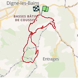
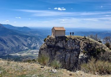
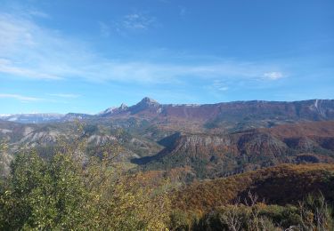
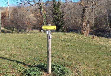
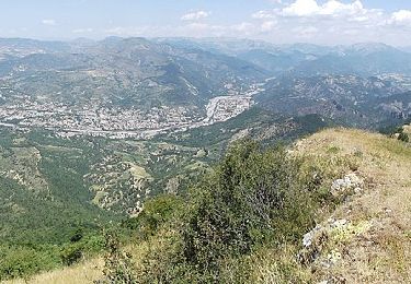
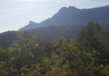
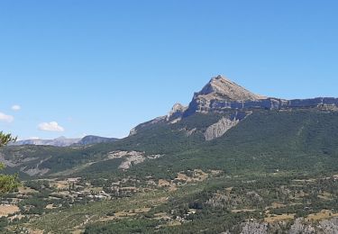
Ce parcours est le 18 km du Trail du Cousson. Le départ s'effectue du Pré Fiaschi situé à 1 km environ du centre de ville sur la route des Thermes. Par des sentiers et des pistes forestières ont accède au sommet du Cousson (1516 m) par le Pas d'Entrages. Avant le sommet vous pourrez voir la Chapelle St Michel du Cousson en équilibre sur un éperon rocheux. Encore quelques mètres à gravir et vous arrivez à un petit cairn qui symbolise le sommet. Et là, une vue époustouflante à 360° avec au nord Les Ecrins, à l'ouest la montagne de Lure et le mont Ventoux et à l'Est la Barre des Dourbes. La descente se fait par le Vallon des Sources

Elevation profile

Photos

Positioning

Country:
France
Region :
Provence-Alpes-Côte d'Azur
Department/Province :
Alpes-de-Haute-Provence
Municipality :
Digne-les-Bains
Location:
Unknown
Start:(UTM)
280310 ; 4884576 (32T) N.

Trails nearby

Trail Walking Digne-les-Bains - Le Cousson - Photo
Walking
Marco05

Walking

Difficult
(1)
Digne-les-Bains, Provence-Alpes-Côte d'Azur, Alpes-de-Haute-Provence, France
15.4 km | 29 km-effort
6h 39min
Yes
Trail Walking Digne-les-Bains - Autour de Courbons - Digne les Bains - Photo
Walking
tracegps

Walking

Medium
(1)
Digne-les-Bains, Provence-Alpes-Côte d'Azur, Alpes-de-Haute-Provence, France
12.6 km | 18.4 km-effort
5h 0min
Yes
Trail Walking Digne-les-Bains - 65bis-Digne- Cousson N et S- Caramantran- Digne  - Photo
Walking
dumotier

Walking

Medium
(1)
Digne-les-Bains, Provence-Alpes-Côte d'Azur, Alpes-de-Haute-Provence, France
17.4 km | 32 km-effort
3h 49min
Yes
Trail Mountain bike Digne-les-Bains - Terres Noires 2011 (50km) - Photo
Mountain bike
tracegps

Mountain bike

Difficult
(2)
Digne-les-Bains, Provence-Alpes-Côte d'Azur, Alpes-de-Haute-Provence, France
46 km | 63 km-effort
5h 0min
Yes
Trail Walking Digne-les-Bains - Chapelle St Pancrace 18.11.23 - Photo
Walking
fredetpascale

Walking

Easy
Digne-les-Bains, Provence-Alpes-Côte d'Azur, Alpes-de-Haute-Provence, France
5.2 km | 8.3 km-effort
1h 50min
Yes
Trail Walking Digne-les-Bains - Rando Col de Peipin Courbons - Photo
Walking
Marchopier

Walking

Medium
Digne-les-Bains, Provence-Alpes-Côte d'Azur, Alpes-de-Haute-Provence, France
18.5 km | 27 km-effort
5h 55min
Yes
Trail On foot Entrages - Le Sommet du Cousson - Photo
On foot
PRO

On foot

Medium
Entrages, Provence-Alpes-Côte d'Azur, Alpes-de-Haute-Provence, France
11.8 km | 21 km-effort
4h 50min
Yes
Trail Walking Marcoux - DIGNE . LES ROBINES DU BANASTRE  n ol - Photo
Walking
RobinMicheline

Walking

Easy
Marcoux, Provence-Alpes-Côte d'Azur, Alpes-de-Haute-Provence, France
11.4 km | 17.2 km-effort
3h 27min
Yes
Trail Walking Digne-les-Bains - ENTRAGES Tour et crête du Feston o s l - Photo
Walking
RobinMicheline

Walking

Medium
Digne-les-Bains, Provence-Alpes-Côte d'Azur, Alpes-de-Haute-Provence, France
12.7 km | 18.7 km-effort
4h 13min
Yes


Close
My subscriptions