


Montboyer 20 nov 2018

bert16
User
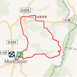

Length
8.3 km

Max alt
146 m

Uphill gradient
157 m
Km-Effort
10.4 km

Min alt
62 m

Downhill gradient
157 m
Boucle
Yes
Creation date :
2019-01-15 19:02:48.688
Updated on :
2019-01-15 19:02:48.688
2h14
Difficulty : Easy

FREE GPS app for hiking
 SityTrail
IGN / Geographical institutes
SityTrail Plus
The world is yours!
About
Trail Walking of 8.3 km to be discovered at New Aquitaine, Charente, Montboyer. This trail is proposed by bert16.
Description
Association des anciens élèves et amis de Brie sous chalais
Positioning
Country:
France
Region :
New Aquitaine
Department/Province :
Charente
Municipality :
Montboyer
Location:
Unknown
Start:(Dec)
Start:(UTM)
270793 ; 5023293 (31T) N.
Comments