


Lons LanotRS

LouisROGER
User GUIDE
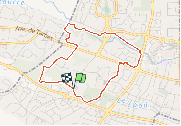

Length
4.6 km

Max alt
206 m

Uphill gradient
34 m
Km-Effort
5 km

Min alt
191 m

Downhill gradient
33 m
Boucle
Yes
Creation date :
2019-01-15 19:17:15.045
Updated on :
2019-01-15 19:17:15.045
1h07
Difficulty : Unknown

FREE GPS app for hiking
 SityTrail
IGN / Geographical institutes
SityTrail Plus
The world is yours!
About
Trail Walking of 4.6 km to be discovered at New Aquitaine, Pyrénées-Atlantiques, Lons. This trail is proposed by LouisROGER.
Positioning
Country:
France
Region :
New Aquitaine
Department/Province :
Pyrénées-Atlantiques
Municipality :
Lons
Location:
Unknown
Start:(Dec)
Start:(UTM)
710989 ; 4800040 (30T) N.
Comments