Trail Walking Tugny-et-Pont - La-pierre-à-Bénie - Photo
 tracegps
tracegps

User

© OpenStreetMap contributors
Length
Length
13.6 km
Max alt
Max alt
87 m
Uphill gradient
Uphill gradient
94 m
Km-Effort
Km-Effort  
14.8 km
Min alt
Min alt
62 m
Downhill gradient
Downhill gradient
92 m
Boucle
Boucle
Yes
Creation date :
2014-12-10 00:00:00.0
Updated on :
2014-12-10 00:00:00.0

(0 Reviews)

Walking
Walking
3h45
Difficulty : Very difficult

Scan this QR Code to open this trail in the SityTrail application

FREE GPS app for hiking

Logo SityTrail SityTrail

IGN / Geographical institutes

Download SityTrail from the App Store Download SityTrail from Google Play

Logo SityTrail SityTrail World

The world is yours!

Download SityTrail from the App Store Download SityTrail from Google Play Download SityTrail on Huawei AppGallery

About

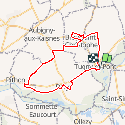
Trail Walking of 13.6 km to be discovered at Hauts-de-France, Aisne, Tugny-et-Pont. This trail is proposed by tracegps.

Description

Homonyme du reptile fabuleux tué par Apollon, le village de Pithon pourrait donner son nom à ce parcours qui s'approche de la vallée de la Somme. Au retour, l'itinéraire longe le mégalithe de la Pierre-à-Bénie. Toutes les infos sont ICI

Elevation profile

Photos

Positioning

Country:
France
Region :
Hauts-de-France
Department/Province :
Aisne
Municipality :
Tugny-et-Pont
Location:
Unknown
Start:(UTM)
511347 ; 5511728 (31U) N.

Trails nearby

Trail Walking Saint-Simon - Le point y - Photo
Walking

Walking

Very easy
Saint-Simon, Hauts-de-France, Aisne, France
6 km | 6.4 km-effort
Unknown
Yes
Trail Walking Seraucourt-le-Grand - Fontaine - Photo
Walking
tracegps

Walking

Medium
Seraucourt-le-Grand, Hauts-de-France, Aisne, France
9.1 km | 9.9 km-effort
2h 30min
Yes
Trail Walking Annois - Les peupleraies du val de Somme - Photo
Walking
tracegps

Walking

Very difficult
Annois, Hauts-de-France, Aisne, France
17.1 km | 18.4 km-effort
4h 30min
Yes
Trail Walking Saint-Simon - Le point Y - Photo
Walking
tracegps

Walking

Easy
Saint-Simon, Hauts-de-France, Aisne, France
6 km | 6.4 km-effort
1h 45min
Yes
Trail Walking Artemps - Artemps 02  - Photo
Walking
José800

Walking

Medium
Artemps, Hauts-de-France, Aisne, France
8.8 km | 9.7 km-effort
2h 13min
Yes
Trail Walking Seraucourt-le-Grand - Saurancourt le grand vendeuil - Photo
Walking
MERMOZ33

Walking

Easy
Seraucourt-le-Grand, Hauts-de-France, Aisne, France
18.5 km | 21 km-effort
4h 25min
No


Close
My subscriptions