Trail Walking Berry-au-Bac - Saint-Rigobert - Photo
 tracegps
tracegps

User

© OpenStreetMap contributors
Length
Length
7 km
Max alt
Max alt
88 m
Uphill gradient
Uphill gradient
74 m
Km-Effort
Km-Effort  
8 km
Min alt
Min alt
50 m
Downhill gradient
Downhill gradient
74 m
Boucle
Boucle
Yes
Creation date :
2014-12-10 00:00:00.0
Updated on :
2014-12-10 00:00:00.0

(1 Reviews)

Walking
Walking
1h45
Difficulty : Medium

Scan this QR Code to open this trail in the SityTrail application

FREE GPS app for hiking

Logo SityTrail SityTrail

IGN / Geographical institutes

Download SityTrail from the App Store Download SityTrail from Google Play

Logo SityTrail SityTrail World

The world is yours!

Download SityTrail from the App Store Download SityTrail from Google Play Download SityTrail on Huawei AppGallery

About

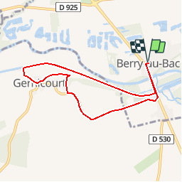
Trail Walking of 7 km to be discovered at Hauts-de-France, Aisne, Berry-au-Bac. This trail is proposed by tracegps.

Description

La région de Berry-au-Bac porte l'empreinte des heures dramatiques de son passé, dont témoignent les croix blanches du cimetière militaire, visible au retour, un camp d'aviation de la Seconde Guerre mondiale, ainsi qu'un monument aux chars d'assaut à l'entrée du Chemin des Dames. Après l'écluse et les berges du canal, le circuit revient par la chapelle et la fontaine de dévotion Saint-Rigobert. Toutes les infos sont ICI

Elevation profile

Photos

Positioning

Country:
France
Region :
Hauts-de-France
Department/Province :
Aisne
Municipality :
Berry-au-Bac
Location:
Unknown
Start:(Dec)
Start:(UTM)
565291 ; 5472671 (31U) N.

Comments

Please log in to post a review or rate the element


Belle balade facile , dommage que le début du parcours ne soit pas bien défriché (le long du canal)


Trails nearby

Trail Walking Berry-au-Bac - La Via Francigena -  Berry au Bac - Reims   - Photo
Walking
tracegps

Walking

Medium
(1)
Berry-au-Bac, Hauts-de-France, Aisne, France
28 km | 32 km-effort
5h 40min
No
Trail Walking Villeneuve-sur-Aisne - le tour de Guignicourt 2 - Photo
Walking
mick211

Walking

Very easy
Villeneuve-sur-Aisne, Hauts-de-France, Aisne, France
7.3 km | 8 km-effort
2h 30min
Yes
Trail Walking Villeneuve-sur-Aisne - Le moulin Brûlé - Photo
Walking
tracegps

Walking

Medium
Villeneuve-sur-Aisne, Hauts-de-France, Aisne, France
11.8 km | 13.3 km-effort
3h 15min
Yes
Trail Walking Villeneuve-sur-Aisne - Guignicourt - La Ligne AR bois en vain 8.8 km - Photo
Walking
mick211

Walking

Medium
Villeneuve-sur-Aisne, Hauts-de-France, Aisne, France
8.6 km | 9.4 km-effort
2h 7min
Yes
Trail On foot Villeneuve-sur-Aisne - Guignicourt-Menneville - Photo
On foot
mick211

On foot

Very easy
Villeneuve-sur-Aisne, Hauts-de-France, Aisne, France
8.8 km | 9.5 km-effort
2h 0min
Yes
Trail Walking Berry-au-Bac - Berry au Bac - Merfy  - Photo
Walking
VANDERPUTTENMi

Walking

Very easy
Berry-au-Bac, Hauts-de-France, Aisne, France
21 km | 25 km-effort
5h 19min
No
Trail Walking Villeneuve-sur-Aisne - Guignicourt Prouvais AR - Photo
Walking
mick211

Walking

Medium
Villeneuve-sur-Aisne, Hauts-de-France, Aisne, France
8.2 km | 9.9 km-effort
2h 9min
Yes
Trail Walking Villeneuve-sur-Aisne - le tour de Guignicourt 3 - Photo
Walking
mick211

Walking

Very easy
Villeneuve-sur-Aisne, Hauts-de-France, Aisne, France
7.5 km | 8.2 km-effort
1h 49min
Yes
Trail Walking Villeneuve-sur-Aisne - Guignicourt Prouvais 7.5 km - Photo
Walking
mick211

Walking

Easy
Villeneuve-sur-Aisne, Hauts-de-France, Aisne, France
7.5 km | 9.4 km-effort
2h 15min
Yes


Close
My subscriptions